You are here: Home > Network List > KZ - Kazakhstan Network Stations List
> Station CHK Chkalovo, Kazakstan > Earthquake Result Viewer
CHK Chkalovo, Kazakstan - Earthquake Result Viewer
| Earthquake location: |
Greenland Sea |
| Earthquake latitude/longitude: |
79.9/1.9 |
| Earthquake time(UTC): |
1998/03/21 (080) 16:33:11 GMT |
| Earthquake Depth: |
10 km |
| Earthquake Magnitude: |
5.9 MB, 6.1 MS, 6.2 UNKNOWN, 6.2 MW |
| Earthquake Catalog/Contributor: |
WHDF/NEIC |
|
| Network: |
KZ Kazakhstan Network |
| Station: |
CHK Chkalovo, Kazakstan |
| Lat/Lon: |
53.68 N/70.62 E |
| Elevation: |
120 m |
|
| Distance: |
34.0 deg |
| Az: |
97.205 deg |
| Baz: |
342.861 deg |
| Ray Param: |
0.07795721 |
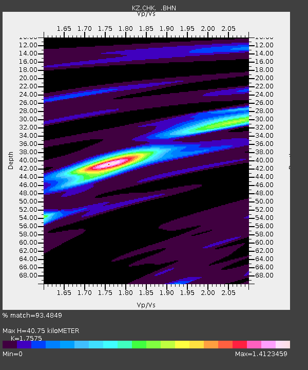
| Estimated Moho Depth: |
40.75 km |
| Estimated Crust Vp/Vs: |
1.76 |
| Assumed Crust Vp: |
6.552 km/s |
| Estimated Crust Vs: |
3.728 km/s |
| Estimated Crust Poisson's Ratio: |
0.26 |
|
| Radial Match: |
93.4849 % |
| Radial Bump: |
299 |
| Transverse Match: |
83.08124 % |
| Transverse Bump: |
400 |
| SOD ConfigId: |
6273 |
| Insert Time: |
2010-03-09 08:56:10.935 +0000 |
| GWidth: |
2.5 |
| Max Bumps: |
400 |
| Tol: |
0.001 |
|

Signal To Noise
| Channel | StoN | STA | LTA |
| KZ:CHK: :BHN:19980321T16:39:23.911011Z | 3.1379375 | 1.261456E-7 | 4.020016E-8 |
| KZ:CHK: :BHE:19980321T16:39:23.911011Z | 0.86398226 | 4.4595616E-8 | 5.1616357E-8 |
| KZ:CHK: :BHZ:19980321T16:39:23.911011Z | 3.2550251 | 2.2232528E-7 | 6.830217E-8 |
| Arrivals |
| Ps | 5.1 SECOND |
| PpPs | 16 SECOND |
| PsPs/PpSs | 21 SECOND |


