You are here: Home > Network List > AV - Alaska Volcano Observatory Stations List
> Station ETKA Kagalaska Island, Regional Station, Alaska > Earthquake Result Viewer
ETKA Kagalaska Island, Regional Station, Alaska - Earthquake Result Viewer
| Earthquake location: |
Northern Molucca Sea |
| Earthquake latitude/longitude: |
0.3/126.3 |
| Earthquake time(UTC): |
2021/06/03 (154) 10:09:55 GMT |
| Earthquake Depth: |
9.9 km |
| Earthquake Magnitude: |
6.1 Mww |
| Earthquake Catalog/Contributor: |
NEIC PDE/us |
|
| Network: |
AV Alaska Volcano Observatory |
| Station: |
ETKA Kagalaska Island, Regional Station, Alaska |
| Lat/Lon: |
51.86 N/176.41 W |
| Elevation: |
290 m |
|
| Distance: |
70.1 deg |
| Az: |
33.68 deg |
| Baz: |
243.411 deg |
| Ray Param: |
0.055193283 |
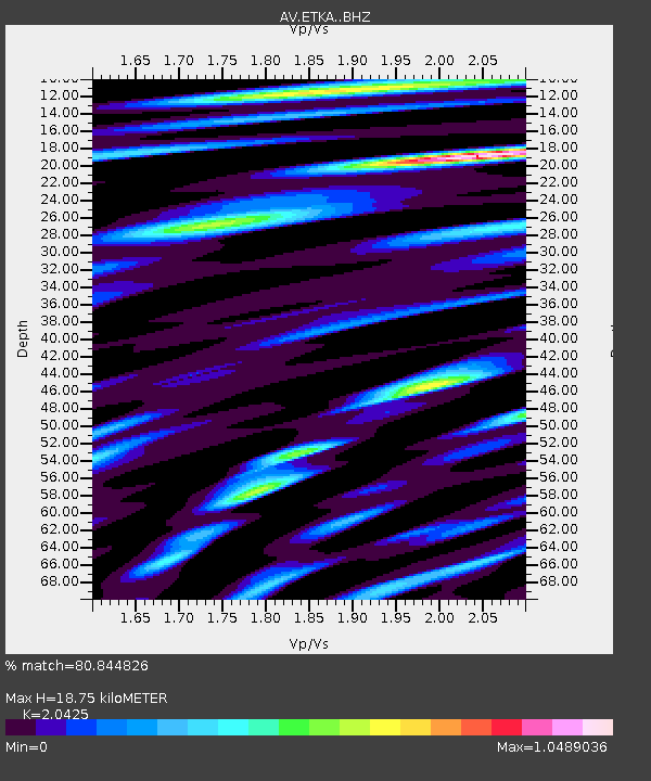
| Estimated Moho Depth: |
18.75 km |
| Estimated Crust Vp/Vs: |
2.04 |
| Assumed Crust Vp: |
5.88 km/s |
| Estimated Crust Vs: |
2.879 km/s |
| Estimated Crust Poisson's Ratio: |
0.34 |
|
| Radial Match: |
80.844826 % |
| Radial Bump: |
400 |
| Transverse Match: |
79.28804 % |
| Transverse Bump: |
400 |
| SOD ConfigId: |
25131211 |
| Insert Time: |
2021-06-17 10:15:17.411 +0000 |
| GWidth: |
2.5 |
| Max Bumps: |
400 |
| Tol: |
0.001 |
|

Signal To Noise
| Channel | StoN | STA | LTA |
| AV:ETKA: :BHZ:20210603T10:20:37.31899Z | 8.188915 | 1.0576651E-6 | 1.2915815E-7 |
| AV:ETKA: :BHN:20210603T10:20:37.31899Z | 1.6776675 | 2.9464127E-7 | 1.7562554E-7 |
| AV:ETKA: :BHE:20210603T10:20:37.31899Z | 4.156305 | 4.5033553E-7 | 1.0834997E-7 |
| Arrivals |
| Ps | 3.4 SECOND |
| PpPs | 9.4 SECOND |
| PsPs/PpSs | 13 SECOND |


