You are here: Home > Network List > AV - Alaska Volcano Observatory Stations List
> Station KABU KABU - Katmai Volcanic Cluster, Alaska > Earthquake Result Viewer
KABU KABU - Katmai Volcanic Cluster, Alaska - Earthquake Result Viewer
| Earthquake location: |
Northern Molucca Sea |
| Earthquake latitude/longitude: |
0.3/126.3 |
| Earthquake time(UTC): |
2021/06/03 (154) 10:09:55 GMT |
| Earthquake Depth: |
9.9 km |
| Earthquake Magnitude: |
6.1 Mww |
| Earthquake Catalog/Contributor: |
NEIC PDE/us |
|
| Network: |
AV Alaska Volcano Observatory |
| Station: |
KABU KABU - Katmai Volcanic Cluster, Alaska |
| Lat/Lon: |
58.27 N/155.28 W |
| Elevation: |
1065 m |
|
| Distance: |
83.6 deg |
| Az: |
31.389 deg |
| Baz: |
260.26 deg |
| Ray Param: |
0.046056706 |
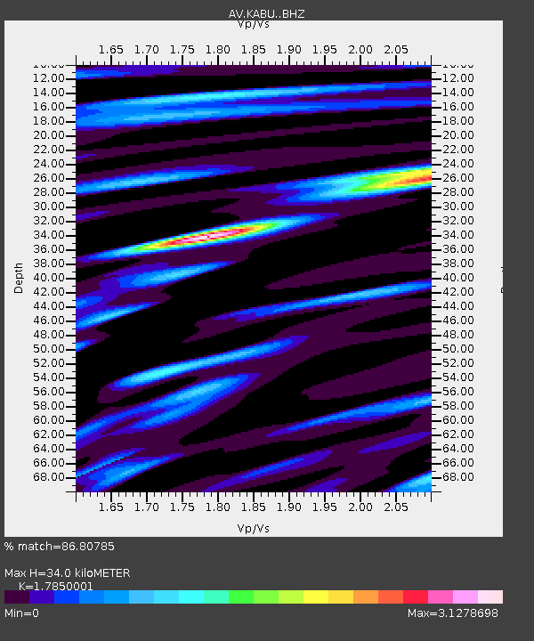
| Estimated Moho Depth: |
34.0 km |
| Estimated Crust Vp/Vs: |
1.79 |
| Assumed Crust Vp: |
6.438 km/s |
| Estimated Crust Vs: |
3.607 km/s |
| Estimated Crust Poisson's Ratio: |
0.27 |
|
| Radial Match: |
86.80785 % |
| Radial Bump: |
400 |
| Transverse Match: |
89.8886 % |
| Transverse Bump: |
400 |
| SOD ConfigId: |
25131211 |
| Insert Time: |
2021-06-17 10:15:41.445 +0000 |
| GWidth: |
2.5 |
| Max Bumps: |
400 |
| Tol: |
0.001 |
|
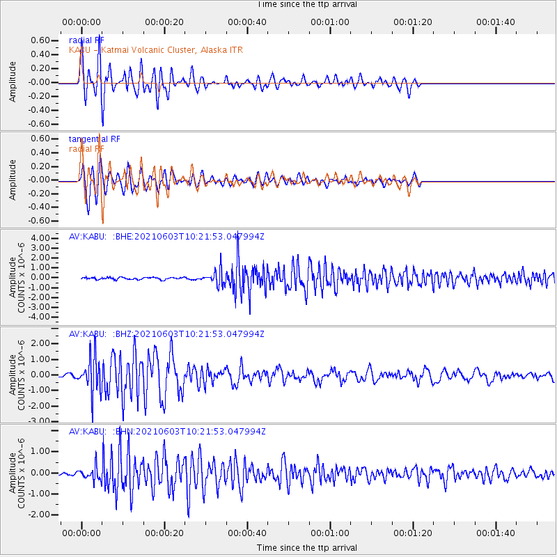
Signal To Noise
| Channel | StoN | STA | LTA |
| AV:KABU: :BHZ:20210603T10:21:53.047994Z | 10.485435 | 1.1347319E-6 | 1.0821982E-7 |
| AV:KABU: :BHN:20210603T10:21:53.047994Z | 4.165083 | 2.971541E-7 | 7.1344104E-8 |
| AV:KABU: :BHE:20210603T10:21:53.047994Z | 7.515948 | 7.497208E-7 | 9.975067E-8 |
| Arrivals |
| Ps | 4.3 SECOND |
| PpPs | 14 SECOND |
| PsPs/PpSs | 19 SECOND |


