You are here: Home > Network List > AV - Alaska Volcano Observatory Stations List
> Station KOKL Mount Kliuchef, Korovin Volcano, Alaska > Earthquake Result Viewer
KOKL Mount Kliuchef, Korovin Volcano, Alaska - Earthquake Result Viewer
| Earthquake location: |
Northern Molucca Sea |
| Earthquake latitude/longitude: |
0.3/126.3 |
| Earthquake time(UTC): |
2021/06/03 (154) 10:09:55 GMT |
| Earthquake Depth: |
9.9 km |
| Earthquake Magnitude: |
6.1 Mww |
| Earthquake Catalog/Contributor: |
NEIC PDE/us |
|
| Network: |
AV Alaska Volcano Observatory |
| Station: |
KOKL Mount Kliuchef, Korovin Volcano, Alaska |
| Lat/Lon: |
52.32 N/174.20 W |
| Elevation: |
758 m |
|
| Distance: |
71.6 deg |
| Az: |
33.864 deg |
| Baz: |
245.207 deg |
| Ray Param: |
0.05424962 |
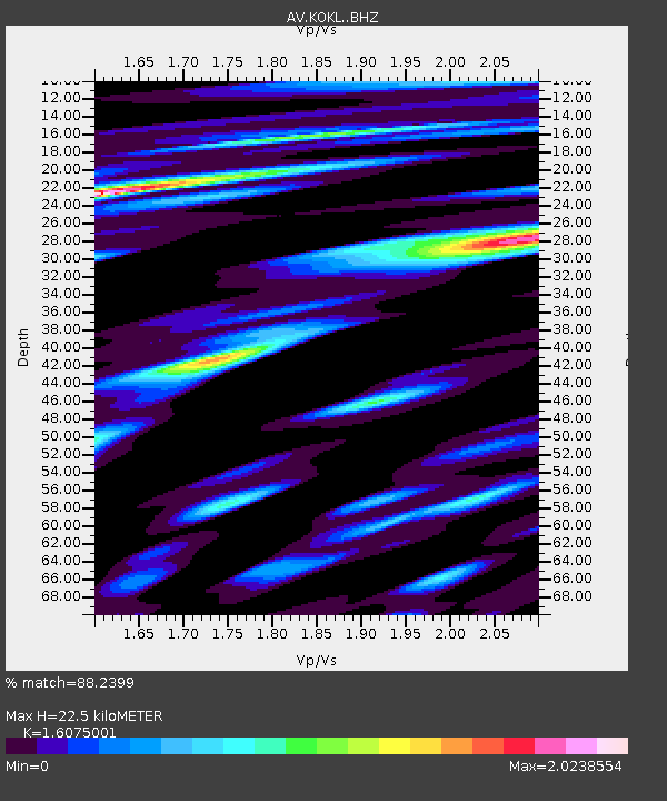
| Estimated Moho Depth: |
22.5 km |
| Estimated Crust Vp/Vs: |
1.61 |
| Assumed Crust Vp: |
5.88 km/s |
| Estimated Crust Vs: |
3.658 km/s |
| Estimated Crust Poisson's Ratio: |
0.18 |
|
| Radial Match: |
88.2399 % |
| Radial Bump: |
374 |
| Transverse Match: |
62.487926 % |
| Transverse Bump: |
400 |
| SOD ConfigId: |
25131211 |
| Insert Time: |
2021-06-17 10:16:00.907 +0000 |
| GWidth: |
2.5 |
| Max Bumps: |
400 |
| Tol: |
0.001 |
|

Signal To Noise
| Channel | StoN | STA | LTA |
| AV:KOKL: :BHZ:20210603T10:20:45.980Z | 6.4874406 | 1.5729516E-6 | 2.4246106E-7 |
| AV:KOKL: :BHN:20210603T10:20:45.980Z | 3.9889092 | 1.0895534E-6 | 2.7314567E-7 |
| AV:KOKL: :BHE:20210603T10:20:45.980Z | 7.5384655 | 1.4840664E-6 | 1.9686584E-7 |
| Arrivals |
| Ps | 2.4 SECOND |
| PpPs | 9.7 SECOND |
| PsPs/PpSs | 12 SECOND |


