You are here: Home > Network List > AV - Alaska Volcano Observatory Stations List
> Station MTBL Table Top, Makushin Volcano, Alaska > Earthquake Result Viewer
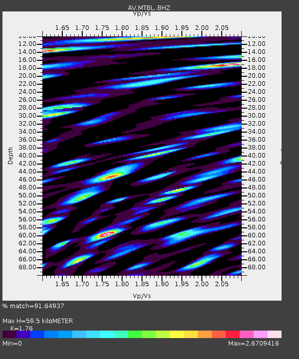
MTBL Table Top, Makushin Volcano, Alaska - Earthquake Result Viewer
| Earthquake location: |
Northern Molucca Sea |
| Earthquake latitude/longitude: |
0.3/126.3 |
| Earthquake time(UTC): |
2021/06/03 (154) 10:09:55 GMT |
| Earthquake Depth: |
9.9 km |
| Earthquake Magnitude: |
6.1 Mww |
| Earthquake Catalog/Contributor: |
NEIC PDE/us |
|
| Network: |
AV Alaska Volcano Observatory |
| Station: |
MTBL Table Top, Makushin Volcano, Alaska |
| Lat/Lon: |
53.97 N/166.68 W |
| Elevation: |
810 m |
|
| Distance: |
76.4 deg |
| Az: |
34.021 deg |
| Baz: |
251.257 deg |
| Ray Param: |
0.05103618 |
| Estimated Moho Depth: |
59.5 km |
| Estimated Crust Vp/Vs: |
1.76 |
| Assumed Crust Vp: |
3.943 km/s |
| Estimated Crust Vs: |
2.241 km/s |
| Estimated Crust Poisson's Ratio: |
0.26 |
|
| Radial Match: |
91.64937 % |
| Radial Bump: |
400 |
| Transverse Match: |
91.37513 % |
| Transverse Bump: |
400 |
| SOD ConfigId: |
25131211 |
| Insert Time: |
2021-06-17 10:16:18.513 +0000 |
| GWidth: |
2.5 |
| Max Bumps: |
400 |
| Tol: |
0.001 |
|

Signal To Noise
| Channel | StoN | STA | LTA |
| AV:MTBL: :BHZ:20210603T10:21:14.060018Z | 17.376291 | 4.4546327E-6 | 2.563627E-7 |
| AV:MTBL: :BHN:20210603T10:21:14.060018Z | 10.688966 | 5.1188504E-6 | 4.788911E-7 |
| AV:MTBL: :BHE:20210603T10:21:14.060018Z | 5.351657 | 3.6761162E-6 | 6.869118E-7 |
| Arrivals |
| Ps | 12 SECOND |
| PpPs | 41 SECOND |
| PsPs/PpSs | 53 SECOND |


