You are here: Home > Network List > CN - Canadian National Seismograph Network Stations List
> Station INK INUVIK, NT > Earthquake Result Viewer
INK INUVIK, NT - Earthquake Result Viewer
*The percent match for this event was below the threshold and hence no stack was calculated.
| Earthquake location: |
Northern Molucca Sea |
| Earthquake latitude/longitude: |
0.3/126.3 |
| Earthquake time(UTC): |
2021/06/03 (154) 10:09:55 GMT |
| Earthquake Depth: |
9.9 km |
| Earthquake Magnitude: |
6.1 Mww |
| Earthquake Catalog/Contributor: |
NEIC PDE/us |
|
| Network: |
CN Canadian National Seismograph Network |
| Station: |
INK INUVIK, NT |
| Lat/Lon: |
68.31 N/133.53 W |
| Elevation: |
44 m |
|
| Distance: |
93.5 deg |
| Az: |
21.509 deg |
| Baz: |
279.538 deg |
| Ray Param: |
$rayparam |
*The percent match for this event was below the threshold and hence was not used in the summary stack. |
|
| Radial Match: |
73.96367 % |
| Radial Bump: |
400 |
| Transverse Match: |
61.220753 % |
| Transverse Bump: |
400 |
| SOD ConfigId: |
25131211 |
| Insert Time: |
2021-06-17 10:17:29.642 +0000 |
| GWidth: |
2.5 |
| Max Bumps: |
400 |
| Tol: |
0.001 |
|
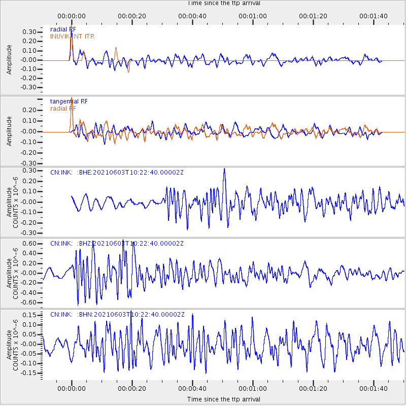
Signal To Noise
| Channel | StoN | STA | LTA |
| CN:INK: :BHZ:20210603T10:22:40.00002Z | 4.638374 | 2.901497E-7 | 6.255418E-8 |
| CN:INK: :BHN:20210603T10:22:40.00002Z | 1.4747251 | 4.7431982E-8 | 3.216327E-8 |
| CN:INK: :BHE:20210603T10:22:40.00002Z | 2.2162993 | 8.7977725E-8 | 3.9695774E-8 |
| Arrivals |
| Ps | |
| PpPs | |
| PsPs/PpSs | |


