You are here: Home > Network List > UU - University of Utah Regional Network Stations List
> Station FORU South Mineral Mountains, UT, USA > Earthquake Result Viewer
FORU South Mineral Mountains, UT, USA - Earthquake Result Viewer
*The percent match for this event was below the threshold and hence no stack was calculated.
| Earthquake location: |
Tonga Islands |
| Earthquake latitude/longitude: |
-16.1/-174.0 |
| Earthquake time(UTC): |
2017/12/08 (342) 23:42:09 GMT |
| Earthquake Depth: |
117 km |
| Earthquake Magnitude: |
5.7 mb |
| Earthquake Catalog/Contributor: |
NEIC PDE/us |
|
| Network: |
UU University of Utah Regional Network |
| Station: |
FORU South Mineral Mountains, UT, USA |
| Lat/Lon: |
38.46 N/112.86 W |
| Elevation: |
1840 m |
|
| Distance: |
78.8 deg |
| Az: |
44.472 deg |
| Baz: |
239.057 deg |
| Ray Param: |
$rayparam |
*The percent match for this event was below the threshold and hence was not used in the summary stack. |
|
| Radial Match: |
66.921234 % |
| Radial Bump: |
400 |
| Transverse Match: |
59.577103 % |
| Transverse Bump: |
400 |
| SOD ConfigId: |
2429771 |
| Insert Time: |
2017-12-22 23:46:55.031 +0000 |
| GWidth: |
2.5 |
| Max Bumps: |
400 |
| Tol: |
0.001 |
|
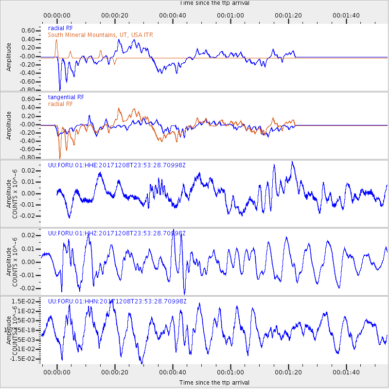
Signal To Noise
| Channel | StoN | STA | LTA |
| UU:FORU:01:HHZ:20171208T23:53:28.70998Z | 2.425284 | 1.05688125E-8 | 4.3577626E-9 |
| UU:FORU:01:HHN:20171208T23:53:28.70998Z | 1.7740817 | 7.346498E-9 | 4.141014E-9 |
| UU:FORU:01:HHE:20171208T23:53:28.70998Z | 0.84058154 | 6.586964E-9 | 7.836198E-9 |
| Arrivals |
| Ps | |
| PpPs | |
| PsPs/PpSs | |


