You are here: Home > Network List > AV - Alaska Volcano Observatory Stations List
> Station ETKA Kagalaska Island, Regional Station, Alaska > Earthquake Result Viewer
ETKA Kagalaska Island, Regional Station, Alaska - Earthquake Result Viewer
| Earthquake location: |
Qinghai, China |
| Earthquake latitude/longitude: |
34.5/99.1 |
| Earthquake time(UTC): |
2021/05/21 (141) 18:13:01 GMT |
| Earthquake Depth: |
10 km |
| Earthquake Magnitude: |
5.5 mb |
| Earthquake Catalog/Contributor: |
NEIC PDE/us |
|
| Network: |
AV Alaska Volcano Observatory |
| Station: |
ETKA Kagalaska Island, Regional Station, Alaska |
| Lat/Lon: |
51.86 N/176.41 W |
| Elevation: |
290 m |
|
| Distance: |
60.6 deg |
| Az: |
45.125 deg |
| Baz: |
289.269 deg |
| Ray Param: |
0.06144924 |
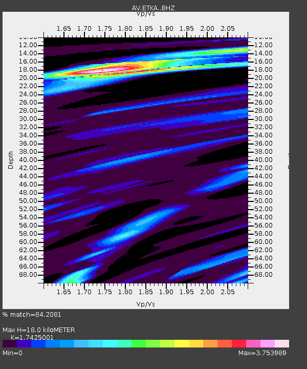
| Estimated Moho Depth: |
18.0 km |
| Estimated Crust Vp/Vs: |
1.74 |
| Assumed Crust Vp: |
5.88 km/s |
| Estimated Crust Vs: |
3.375 km/s |
| Estimated Crust Poisson's Ratio: |
0.25 |
|
| Radial Match: |
84.2081 % |
| Radial Bump: |
400 |
| Transverse Match: |
49.22404 % |
| Transverse Bump: |
376 |
| SOD ConfigId: |
25131211 |
| Insert Time: |
2021-06-17 18:50:06.060 +0000 |
| GWidth: |
2.5 |
| Max Bumps: |
400 |
| Tol: |
0.001 |
|

Signal To Noise
| Channel | StoN | STA | LTA |
| AV:ETKA: :BHZ:20210521T18:22:40.680001Z | 0.31192696 | 7.400648E-7 | 2.372558E-6 |
| AV:ETKA: :BHN:20210521T18:22:40.680001Z | 1.25407 | 2.8427994E-6 | 2.2668587E-6 |
| AV:ETKA: :BHE:20210521T18:22:40.680001Z | 2.0262322 | 6.2781746E-6 | 3.098448E-6 |
| Arrivals |
| Ps | 2.4 SECOND |
| PpPs | 8.1 SECOND |
| PsPs/PpSs | 10 SECOND |


