You are here: Home > Network List > AV - Alaska Volcano Observatory Stations List
> Station GSIG Igitkin Island, Great Sitkin Volcano, Alaska > Earthquake Result Viewer
GSIG Igitkin Island, Great Sitkin Volcano, Alaska - Earthquake Result Viewer
| Earthquake location: |
Qinghai, China |
| Earthquake latitude/longitude: |
34.5/99.1 |
| Earthquake time(UTC): |
2021/05/21 (141) 18:13:01 GMT |
| Earthquake Depth: |
10 km |
| Earthquake Magnitude: |
5.5 mb |
| Earthquake Catalog/Contributor: |
NEIC PDE/us |
|
| Network: |
AV Alaska Volcano Observatory |
| Station: |
GSIG Igitkin Island, Great Sitkin Volcano, Alaska |
| Lat/Lon: |
51.99 N/175.93 W |
| Elevation: |
407 m |
|
| Distance: |
60.8 deg |
| Az: |
44.877 deg |
| Baz: |
289.525 deg |
| Ray Param: |
0.061290212 |
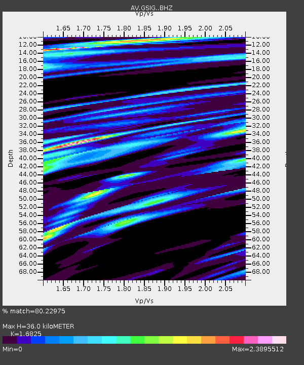
| Estimated Moho Depth: |
36.0 km |
| Estimated Crust Vp/Vs: |
1.68 |
| Assumed Crust Vp: |
3.943 km/s |
| Estimated Crust Vs: |
2.344 km/s |
| Estimated Crust Poisson's Ratio: |
0.23 |
|
| Radial Match: |
80.22975 % |
| Radial Bump: |
400 |
| Transverse Match: |
40.065304 % |
| Transverse Bump: |
400 |
| SOD ConfigId: |
25131211 |
| Insert Time: |
2021-06-17 18:50:17.262 +0000 |
| GWidth: |
2.5 |
| Max Bumps: |
400 |
| Tol: |
0.001 |
|
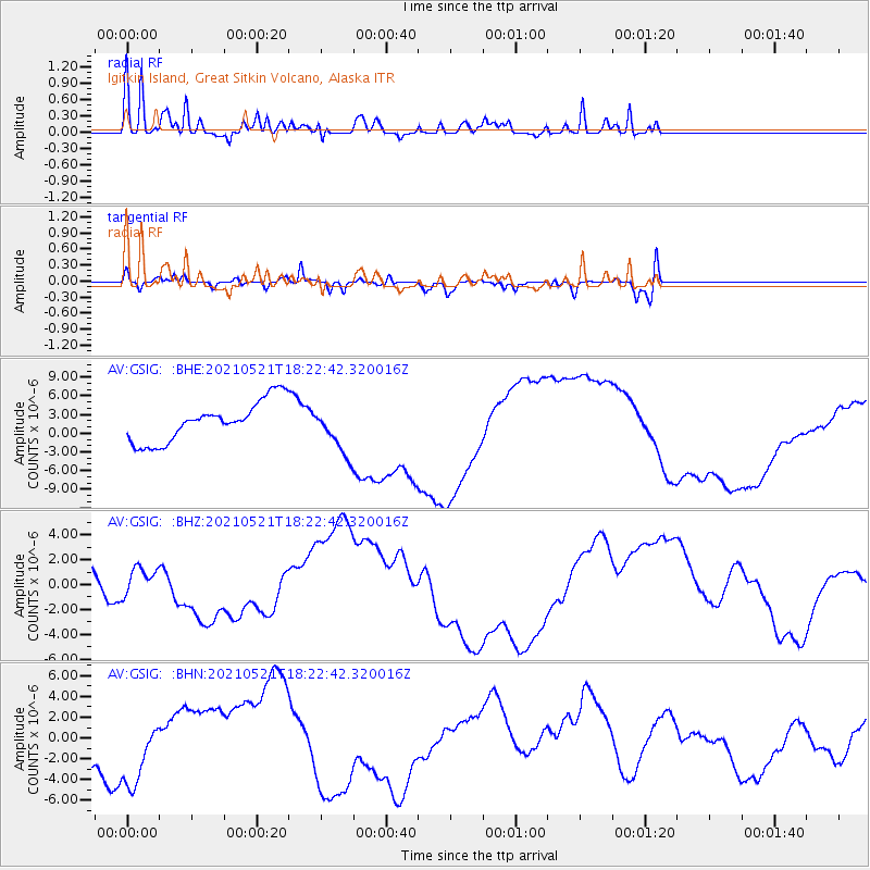
Signal To Noise
| Channel | StoN | STA | LTA |
| AV:GSIG: :BHZ:20210521T18:22:42.320016Z | 0.55178076 | 1.1178785E-6 | 2.025947E-6 |
| AV:GSIG: :BHN:20210521T18:22:42.320016Z | 1.460024 | 3.3393976E-6 | 2.287221E-6 |
| AV:GSIG: :BHE:20210521T18:22:42.320016Z | 1.1793816 | 3.7516663E-6 | 3.1810455E-6 |
| Arrivals |
| Ps | 6.3 SECOND |
| PpPs | 24 SECOND |
| PsPs/PpSs | 30 SECOND |


