You are here: Home > Network List > AV - Alaska Volcano Observatory Stations List
> Station TAFL Flats, Tanaga Volcano, Alaska > Earthquake Result Viewer
TAFL Flats, Tanaga Volcano, Alaska - Earthquake Result Viewer
| Earthquake location: |
Qinghai, China |
| Earthquake latitude/longitude: |
34.5/99.1 |
| Earthquake time(UTC): |
2021/05/21 (141) 18:13:01 GMT |
| Earthquake Depth: |
10 km |
| Earthquake Magnitude: |
5.5 mb |
| Earthquake Catalog/Contributor: |
NEIC PDE/us |
|
| Network: |
AV Alaska Volcano Observatory |
| Station: |
TAFL Flats, Tanaga Volcano, Alaska |
| Lat/Lon: |
51.76 N/177.90 W |
| Elevation: |
186 m |
|
| Distance: |
59.7 deg |
| Az: |
45.584 deg |
| Baz: |
288.328 deg |
| Ray Param: |
0.061989702 |
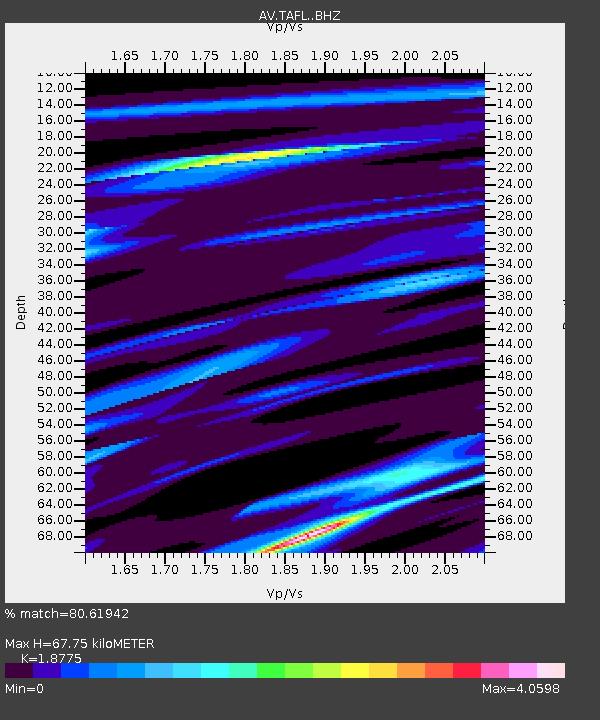
| Estimated Moho Depth: |
67.75 km |
| Estimated Crust Vp/Vs: |
1.88 |
| Assumed Crust Vp: |
5.88 km/s |
| Estimated Crust Vs: |
3.132 km/s |
| Estimated Crust Poisson's Ratio: |
0.30 |
|
| Radial Match: |
80.61942 % |
| Radial Bump: |
400 |
| Transverse Match: |
51.950344 % |
| Transverse Bump: |
400 |
| SOD ConfigId: |
25131211 |
| Insert Time: |
2021-06-17 18:51:05.991 +0000 |
| GWidth: |
2.5 |
| Max Bumps: |
400 |
| Tol: |
0.001 |
|

Signal To Noise
| Channel | StoN | STA | LTA |
| AV:TAFL: :BHZ:20210521T18:22:34.919992Z | 0.74011517 | 2.9061955E-6 | 3.92668E-6 |
| AV:TAFL: :BHN:20210521T18:22:34.919992Z | 1.1981517 | 5.4000166E-6 | 4.5069555E-6 |
| AV:TAFL: :BHE:20210521T18:22:34.919992Z | 3.319342 | 1.1691533E-5 | 3.5222442E-6 |
| Arrivals |
| Ps | 10 SECOND |
| PpPs | 32 SECOND |
| PsPs/PpSs | 42 SECOND |


