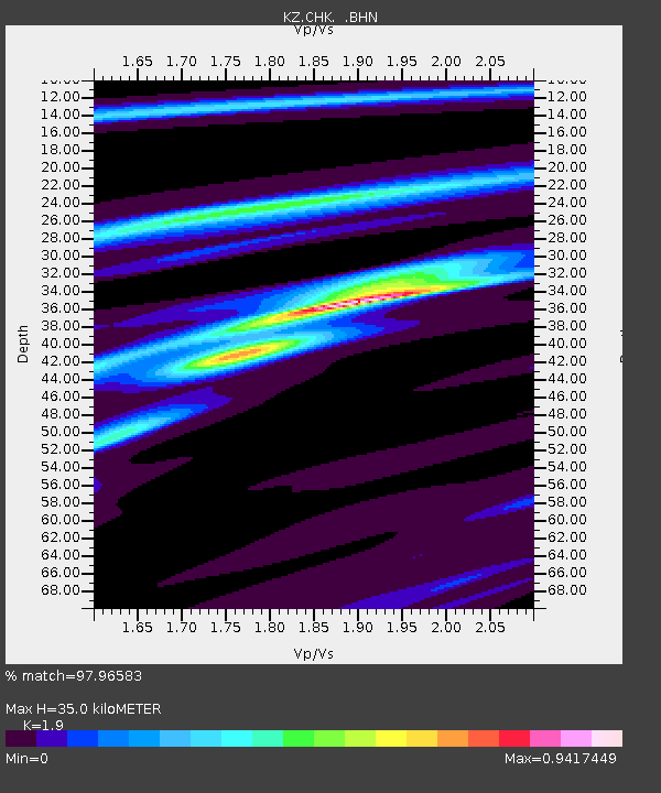
CHK Chkalovo, Kazakstan - Earthquake Result Viewer

Earthquake location: Near East Coast Of Kamchatka
Earthquake latitude/longitude: 54.8/162.0
Earthquake time(UTC): 1997/12/05 (339) 11:26:54 GMT
Earthquake Depth: 33 km
Earthquake Magnitude: 6.3 MB, 7.6 MS, 7.9 UNKNOWN, 7.3 ME
Earthquake Catalog/Contributor: WHDF/NEIC
Network: KZ Kazakhstan Network
Station: CHK Chkalovo, Kazakstan
Lat/Lon: 53.68 N/70.62 E
Elevation: 120 m
Distance: 49.7 deg
Az: 308.728 deg
Baz: 49.332 deg
Ray Param: 0.06848832
Estimated Moho Depth: 35.0 km
Estimated Crust Vp/Vs: 1.90
Assumed Crust Vp: 6.552 km/s
Estimated Crust Vs: 3.449 km/s
Estimated Crust Poisson's Ratio: 0.31
Radial Match: 97.96583 %
Radial Bump: 154
Transverse Match: 90.04005 %
Transverse Bump: 400
SOD ConfigId: 4480
Insert Time: 2010-03-09 08:57:49.004 +0000
GWidth: 2.5
Max Bumps: 400
Tol: 0.001

Signal To Noise

ChannelStoNSTALTA
KZ:CHK: :BHN:19971205T11:35:12.606012Z14.3320215.032483E-63.511356E-7
KZ:CHK: :BHE:19971205T11:35:12.606012Z10.1852671.6260361E-61.5964591E-7
KZ:CHK: :BHZ:19971205T11:35:12.606012Z8.1151352.1615779E-62.6636374E-7
Arrivals
Ps5.1 SECOND
PpPs15 SECOND
PsPs/PpSs20 SECOND