You are here: Home > Network List > G - GEOSCOPE Stations List
> Station NOUC Port Laguerre, New Caledonia > Earthquake Result Viewer
NOUC Port Laguerre, New Caledonia - Earthquake Result Viewer
| Earthquake location: |
W. Caroline Islands, Micronesia |
| Earthquake latitude/longitude: |
10.1/140.2 |
| Earthquake time(UTC): |
2017/12/09 (343) 15:14:24 GMT |
| Earthquake Depth: |
10 km |
| Earthquake Magnitude: |
6.1 Mww |
| Earthquake Catalog/Contributor: |
NEIC PDE/us |
|
| Network: |
G GEOSCOPE |
| Station: |
NOUC Port Laguerre, New Caledonia |
| Lat/Lon: |
22.10 S/166.30 E |
| Elevation: |
112 m |
|
| Distance: |
41.0 deg |
| Az: |
141.527 deg |
| Baz: |
318.654 deg |
| Ray Param: |
0.07408306 |
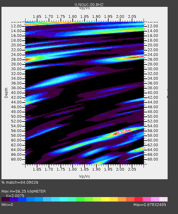
| Estimated Moho Depth: |
56.25 km |
| Estimated Crust Vp/Vs: |
2.01 |
| Assumed Crust Vp: |
5.14 km/s |
| Estimated Crust Vs: |
2.56 km/s |
| Estimated Crust Poisson's Ratio: |
0.33 |
|
| Radial Match: |
84.09026 % |
| Radial Bump: |
393 |
| Transverse Match: |
75.82032 % |
| Transverse Bump: |
400 |
| SOD ConfigId: |
2429771 |
| Insert Time: |
2017-12-23 15:15:19.915 +0000 |
| GWidth: |
2.5 |
| Max Bumps: |
400 |
| Tol: |
0.001 |
|

Signal To Noise
| Channel | StoN | STA | LTA |
| G:NOUC:00:BHZ:20171209T15:21:36.499004Z | 4.3729014 | 1.1023767E-6 | 2.5209275E-7 |
| G:NOUC:00:BHN:20171209T15:21:36.499004Z | 2.4877634 | 3.0820954E-7 | 1.2389022E-7 |
| G:NOUC:00:BHE:20171209T15:21:36.499004Z | 3.071728 | 4.86646E-7 | 1.5842744E-7 |
| Arrivals |
| Ps | 11 SECOND |
| PpPs | 32 SECOND |
| PsPs/PpSs | 43 SECOND |


