You are here: Home > Network List > N4 - Central and EAstern US Network Stations List
> Station F64A Sherman, ME, USA > Earthquake Result Viewer
F64A Sherman, ME, USA - Earthquake Result Viewer
| Earthquake location: |
Off Coast Of Oregon |
| Earthquake latitude/longitude: |
42.3/-126.3 |
| Earthquake time(UTC): |
2021/06/04 (155) 07:52:43 GMT |
| Earthquake Depth: |
17 km |
| Earthquake Magnitude: |
5.9 Mww |
| Earthquake Catalog/Contributor: |
NEIC PDE/us |
|
| Network: |
N4 Central and EAstern US Network |
| Station: |
F64A Sherman, ME, USA |
| Lat/Lon: |
45.86 N/68.35 W |
| Elevation: |
179 m |
|
| Distance: |
41.0 deg |
| Az: |
64.526 deg |
| Baz: |
286.536 deg |
| Ray Param: |
0.074052274 |
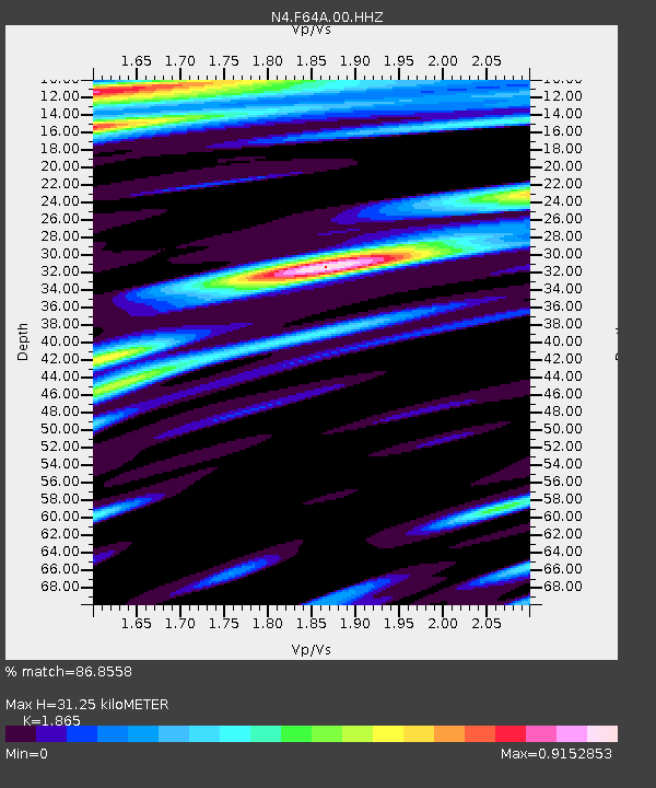
| Estimated Moho Depth: |
31.25 km |
| Estimated Crust Vp/Vs: |
1.87 |
| Assumed Crust Vp: |
6.419 km/s |
| Estimated Crust Vs: |
3.442 km/s |
| Estimated Crust Poisson's Ratio: |
0.30 |
|
| Radial Match: |
86.8558 % |
| Radial Bump: |
400 |
| Transverse Match: |
57.324013 % |
| Transverse Bump: |
400 |
| SOD ConfigId: |
25131211 |
| Insert Time: |
2021-06-18 07:59:56.777 +0000 |
| GWidth: |
2.5 |
| Max Bumps: |
400 |
| Tol: |
0.001 |
|

Signal To Noise
| Channel | StoN | STA | LTA |
| N4:F64A:00:HHZ:20210604T07:59:54.699988Z | 1.8579425 | 2.639083E-7 | 1.420433E-7 |
| N4:F64A:00:HH1:20210604T07:59:54.699988Z | 0.8344131 | 9.3829364E-8 | 1.12449534E-7 |
| N4:F64A:00:HH2:20210604T07:59:54.699988Z | 1.6727926 | 1.4717158E-7 | 8.797957E-8 |
| Arrivals |
| Ps | 4.5 SECOND |
| PpPs | 13 SECOND |
| PsPs/PpSs | 18 SECOND |


