You are here: Home > Network List > N4 - Central and EAstern US Network Stations List
> Station O52A Adamsville, OH, USA > Earthquake Result Viewer
O52A Adamsville, OH, USA - Earthquake Result Viewer
| Earthquake location: |
Off Coast Of Oregon |
| Earthquake latitude/longitude: |
42.3/-126.3 |
| Earthquake time(UTC): |
2021/06/04 (155) 07:52:43 GMT |
| Earthquake Depth: |
17 km |
| Earthquake Magnitude: |
5.9 Mww |
| Earthquake Catalog/Contributor: |
NEIC PDE/us |
|
| Network: |
N4 Central and EAstern US Network |
| Station: |
O52A Adamsville, OH, USA |
| Lat/Lon: |
40.12 N/81.84 W |
| Elevation: |
331 m |
|
| Distance: |
33.2 deg |
| Az: |
78.501 deg |
| Baz: |
288.528 deg |
| Ray Param: |
0.07829757 |
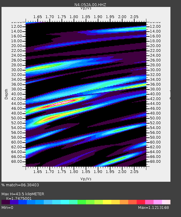
| Estimated Moho Depth: |
43.5 km |
| Estimated Crust Vp/Vs: |
1.75 |
| Assumed Crust Vp: |
6.483 km/s |
| Estimated Crust Vs: |
3.71 km/s |
| Estimated Crust Poisson's Ratio: |
0.26 |
|
| Radial Match: |
86.38403 % |
| Radial Bump: |
381 |
| Transverse Match: |
55.423603 % |
| Transverse Bump: |
400 |
| SOD ConfigId: |
25131211 |
| Insert Time: |
2021-06-18 08:00:33.966 +0000 |
| GWidth: |
2.5 |
| Max Bumps: |
400 |
| Tol: |
0.001 |
|

Signal To Noise
| Channel | StoN | STA | LTA |
| N4:O52A:00:HHZ:20210604T07:58:48.959998Z | 6.853672 | 4.367147E-7 | 6.371982E-8 |
| N4:O52A:00:HH1:20210604T07:58:48.959998Z | 1.1305125 | 9.3901704E-8 | 8.306119E-8 |
| N4:O52A:00:HH2:20210604T07:58:48.959998Z | 4.5856833 | 2.7391746E-7 | 5.973318E-8 |
| Arrivals |
| Ps | 5.4 SECOND |
| PpPs | 17 SECOND |
| PsPs/PpSs | 22 SECOND |


