You are here: Home > Network List > NM - Cooperative New Madrid Seismic Network Stations List
> Station BLO Bloomington, IN > Earthquake Result Viewer
BLO Bloomington, IN - Earthquake Result Viewer
| Earthquake location: |
Off Coast Of Oregon |
| Earthquake latitude/longitude: |
42.3/-126.3 |
| Earthquake time(UTC): |
2021/06/04 (155) 07:52:43 GMT |
| Earthquake Depth: |
17 km |
| Earthquake Magnitude: |
5.9 Mww |
| Earthquake Catalog/Contributor: |
NEIC PDE/us |
|
| Network: |
NM Cooperative New Madrid Seismic Network |
| Station: |
BLO Bloomington, IN |
| Lat/Lon: |
39.17 N/86.52 W |
| Elevation: |
246 m |
|
| Distance: |
30.1 deg |
| Az: |
82.41 deg |
| Baz: |
288.877 deg |
| Ray Param: |
0.079505555 |
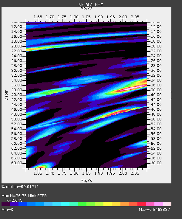
| Estimated Moho Depth: |
36.75 km |
| Estimated Crust Vp/Vs: |
2.05 |
| Assumed Crust Vp: |
6.444 km/s |
| Estimated Crust Vs: |
3.151 km/s |
| Estimated Crust Poisson's Ratio: |
0.34 |
|
| Radial Match: |
90.91711 % |
| Radial Bump: |
310 |
| Transverse Match: |
60.216576 % |
| Transverse Bump: |
393 |
| SOD ConfigId: |
25131211 |
| Insert Time: |
2021-06-18 08:01:35.536 +0000 |
| GWidth: |
2.5 |
| Max Bumps: |
400 |
| Tol: |
0.001 |
|

Signal To Noise
| Channel | StoN | STA | LTA |
| NM:BLO: :HHZ:20210604T07:58:21.560004Z | 5.2371416 | 6.572181E-7 | 1.2549175E-7 |
| NM:BLO: :HHN:20210604T07:58:21.560004Z | 2.3907278 | 1.7205349E-7 | 7.196699E-8 |
| NM:BLO: :HHE:20210604T07:58:21.560004Z | 6.9120946 | 4.1055534E-7 | 5.939666E-8 |
| Arrivals |
| Ps | 6.4 SECOND |
| PpPs | 16 SECOND |
| PsPs/PpSs | 23 SECOND |


