You are here: Home > Network List > US - United States National Seismic Network Stations List
> Station ACSO Alum Creek State Park, Ohio, USA > Earthquake Result Viewer
ACSO Alum Creek State Park, Ohio, USA - Earthquake Result Viewer
| Earthquake location: |
Off Coast Of Oregon |
| Earthquake latitude/longitude: |
42.3/-126.3 |
| Earthquake time(UTC): |
2021/06/04 (155) 07:52:43 GMT |
| Earthquake Depth: |
17 km |
| Earthquake Magnitude: |
5.9 Mww |
| Earthquake Catalog/Contributor: |
NEIC PDE/us |
|
| Network: |
US United States National Seismic Network |
| Station: |
ACSO Alum Creek State Park, Ohio, USA |
| Lat/Lon: |
40.23 N/82.98 W |
| Elevation: |
288 m |
|
| Distance: |
32.4 deg |
| Az: |
78.806 deg |
| Baz: |
288.048 deg |
| Ray Param: |
0.07868481 |
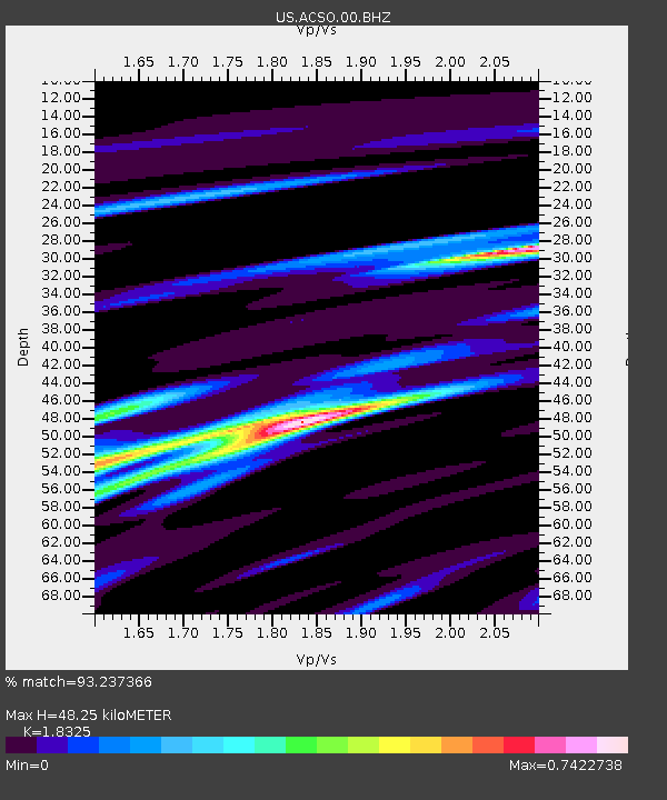
| Estimated Moho Depth: |
48.25 km |
| Estimated Crust Vp/Vs: |
1.83 |
| Assumed Crust Vp: |
6.498 km/s |
| Estimated Crust Vs: |
3.546 km/s |
| Estimated Crust Poisson's Ratio: |
0.29 |
|
| Radial Match: |
93.237366 % |
| Radial Bump: |
363 |
| Transverse Match: |
78.35365 % |
| Transverse Bump: |
400 |
| SOD ConfigId: |
25131211 |
| Insert Time: |
2021-06-18 08:04:40.588 +0000 |
| GWidth: |
2.5 |
| Max Bumps: |
400 |
| Tol: |
0.001 |
|

Signal To Noise
| Channel | StoN | STA | LTA |
| US:ACSO:00:BHZ:20210604T07:58:41.375007Z | 7.042233 | 5.3622466E-7 | 7.6144126E-8 |
| US:ACSO:00:BH1:20210604T07:58:41.375007Z | 2.8473775 | 2.4195282E-7 | 8.497391E-8 |
| US:ACSO:00:BH2:20210604T07:58:41.375007Z | 4.4413157 | 3.066273E-7 | 6.903974E-8 |
| Arrivals |
| Ps | 6.7 SECOND |
| PpPs | 19 SECOND |
| PsPs/PpSs | 26 SECOND |


