You are here: Home > Network List > US - United States National Seismic Network Stations List
> Station LONY Lake Ozonia, New York, USA > Earthquake Result Viewer
LONY Lake Ozonia, New York, USA - Earthquake Result Viewer
| Earthquake location: |
Off Coast Of Oregon |
| Earthquake latitude/longitude: |
42.3/-126.3 |
| Earthquake time(UTC): |
2021/06/04 (155) 07:52:43 GMT |
| Earthquake Depth: |
17 km |
| Earthquake Magnitude: |
5.9 Mww |
| Earthquake Catalog/Contributor: |
NEIC PDE/us |
|
| Network: |
US United States National Seismic Network |
| Station: |
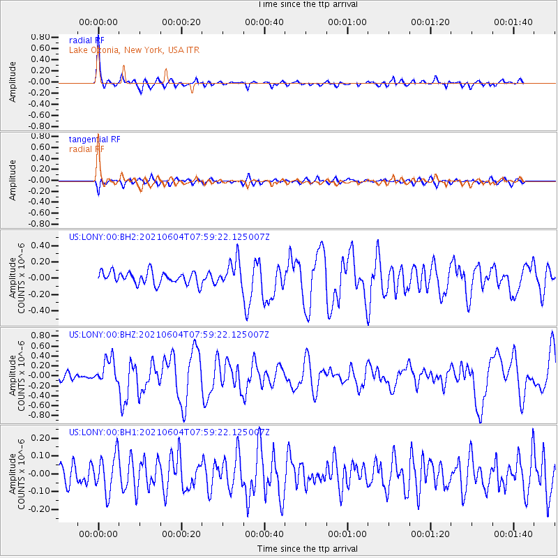
LONY Lake Ozonia, New York, USA |
| Lat/Lon: |
44.62 N/74.58 W |
| Elevation: |
440 m |
|
| Distance: |
37.1 deg |
| Az: |
68.327 deg |
| Baz: |
285.076 deg |
| Ray Param: |
0.07632748 |
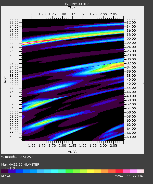
| Estimated Moho Depth: |
22.25 km |
| Estimated Crust Vp/Vs: |
1.60 |
| Assumed Crust Vp: |
6.419 km/s |
| Estimated Crust Vs: |
4.012 km/s |
| Estimated Crust Poisson's Ratio: |
0.18 |
|
| Radial Match: |
90.51057 % |
| Radial Bump: |
360 |
| Transverse Match: |
74.99234 % |
| Transverse Bump: |
400 |
| SOD ConfigId: |
25131211 |
| Insert Time: |
2021-06-18 08:04:51.675 +0000 |
| GWidth: |
2.5 |
| Max Bumps: |
400 |
| Tol: |
0.001 |
|
Signal To Noise
| Channel | StoN | STA | LTA |
| US:LONY:00:BHZ:20210604T07:59:22.125007Z | 3.5905998 | 2.634092E-7 | 7.336077E-8 |
| US:LONY:00:BH1:20210604T07:59:22.125007Z | 2.1207314 | 1.0910891E-7 | 5.144872E-8 |
| US:LONY:00:BH2:20210604T07:59:22.125007Z | 2.1994758 | 1.6407128E-7 | 7.459563E-8 |
| Arrivals |
| Ps | 2.3 SECOND |
| PpPs | 8.3 SECOND |
| PsPs/PpSs | 11 SECOND |


