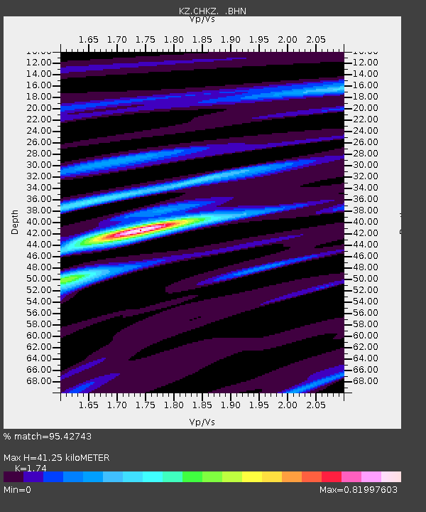
CHKZ Chkalovo, Kazakstan - Earthquake Result Viewer

Earthquake location: Southwestern Ryukyu Isl., Japan
Earthquake latitude/longitude: 23.3/124.2
Earthquake time(UTC): 2000/11/08 (313) 18:36:21 GMT
Earthquake Depth: 14 km
Earthquake Magnitude: 5.7 MB, 5.5 MS, 5.8 MW, 5.6 MW
Earthquake Catalog/Contributor: WHDF/NEIC
Network: KZ Kazakhstan Network
Station: CHKZ Chkalovo, Kazakstan
Lat/Lon: 53.68 N/70.62 E
Elevation: 120 m
Distance: 50.2 deg
Az: 321.452 deg
Baz: 105.552 deg
Ray Param: 0.06823354
Estimated Moho Depth: 41.25 km
Estimated Crust Vp/Vs: 1.74
Assumed Crust Vp: 6.552 km/s
Estimated Crust Vs: 3.766 km/s
Estimated Crust Poisson's Ratio: 0.25
Radial Match: 95.42743 %
Radial Bump: 277
Transverse Match: 73.29638 %
Transverse Bump: 400
SOD ConfigId: 3753
Insert Time: 2010-03-09 09:00:42.737 +0000
GWidth: 2.5
Max Bumps: 400
Tol: 0.001

Signal To Noise

ChannelStoNSTALTA
KZ:CHKZ: :BHN:20001108T18:44:45.575Z1.72461561.2907475E-77.484262E-8
KZ:CHKZ: :BHE:20001108T18:44:45.575Z19.9249956.2959907E-73.1598454E-8
KZ:CHKZ: :BHZ:20001108T18:44:45.575Z20.3527181.2038546E-65.9149574E-8
Arrivals
Ps5.0 SECOND
PpPs16 SECOND
PsPs/PpSs21 SECOND