You are here: Home > Network List > IU - Global Seismograph Network (GSN - IRIS/USGS) Stations List
> Station RSSD Black Hills, South Dakota, USA > Earthquake Result Viewer
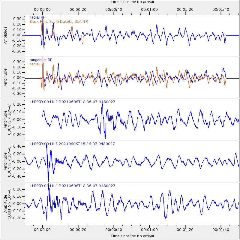
RSSD Black Hills, South Dakota, USA - Earthquake Result Viewer
*The percent match for this event was below the threshold and hence no stack was calculated.
| Earthquake location: |
Fiji Islands Region |
| Earthquake latitude/longitude: |
-15.9/-177.3 |
| Earthquake time(UTC): |
2021/06/06 (157) 18:24:28 GMT |
| Earthquake Depth: |
422 km |
| Earthquake Magnitude: |
5.6 mww |
| Earthquake Catalog/Contributor: |
NEIC PDE/us |
|
| Network: |
IU Global Seismograph Network (GSN - IRIS/USGS) |
| Station: |
RSSD Black Hills, South Dakota, USA |
| Lat/Lon: |
44.12 N/104.04 W |
| Elevation: |
2090 m |
|
| Distance: |
89.4 deg |
| Az: |
43.623 deg |
| Baz: |
247.195 deg |
| Ray Param: |
$rayparam |
*The percent match for this event was below the threshold and hence was not used in the summary stack. |
|
| Radial Match: |
46.357002 % |
| Radial Bump: |
400 |
| Transverse Match: |
67.11792 % |
| Transverse Bump: |
400 |
| SOD ConfigId: |
25131211 |
| Insert Time: |
2021-06-20 18:36:17.976 +0000 |
| GWidth: |
2.5 |
| Max Bumps: |
400 |
| Tol: |
0.001 |
|
Signal To Noise
| Channel | StoN | STA | LTA |
| IU:RSSD:00:HHZ:20210606T18:36:07.948002Z | 3.0548272 | 2.0507848E-7 | 6.7132596E-8 |
| IU:RSSD:00:HH1:20210606T18:36:07.948002Z | 1.8198118 | 1.1944911E-7 | 6.563817E-8 |
| IU:RSSD:00:HH2:20210606T18:36:07.948002Z | 1.9140952 | 1.1071861E-7 | 5.7843838E-8 |
| Arrivals |
| Ps | |
| PpPs | |
| PsPs/PpSs | |


