You are here: Home > Network List > US - United States National Seismic Network Stations List
> Station MNTX Cornudas Mountains, Texas, USA > Earthquake Result Viewer
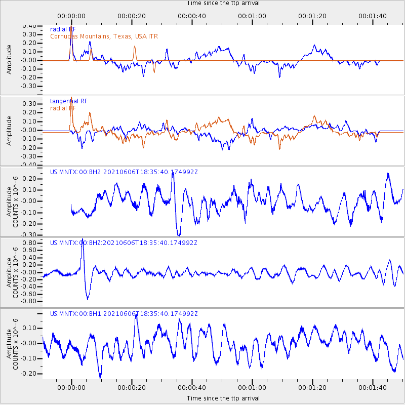
MNTX Cornudas Mountains, Texas, USA - Earthquake Result Viewer
*The percent match for this event was below the threshold and hence no stack was calculated.
| Earthquake location: |
Fiji Islands Region |
| Earthquake latitude/longitude: |
-15.9/-177.3 |
| Earthquake time(UTC): |
2021/06/06 (157) 18:24:28 GMT |
| Earthquake Depth: |
422 km |
| Earthquake Magnitude: |
5.6 mww |
| Earthquake Catalog/Contributor: |
NEIC PDE/us |
|
| Network: |
US United States National Seismic Network |
| Station: |
MNTX Cornudas Mountains, Texas, USA |
| Lat/Lon: |
31.70 N/105.38 W |
| Elevation: |
404 m |
|
| Distance: |
83.6 deg |
| Az: |
54.649 deg |
| Baz: |
247.043 deg |
| Ray Param: |
$rayparam |
*The percent match for this event was below the threshold and hence was not used in the summary stack. |
|
| Radial Match: |
60.88467 % |
| Radial Bump: |
400 |
| Transverse Match: |
37.595818 % |
| Transverse Bump: |
400 |
| SOD ConfigId: |
25131211 |
| Insert Time: |
2021-06-20 18:44:18.766 +0000 |
| GWidth: |
2.5 |
| Max Bumps: |
400 |
| Tol: |
0.001 |
|
Signal To Noise
| Channel | StoN | STA | LTA |
| US:MNTX:00:BHZ:20210606T18:35:40.174992Z | 5.800701 | 3.525808E-7 | 6.078245E-8 |
| US:MNTX:00:BH1:20210606T18:35:40.174992Z | 1.4623199 | 9.162651E-8 | 6.265832E-8 |
| US:MNTX:00:BH2:20210606T18:35:40.174992Z | 1.3144941 | 1.0878952E-7 | 8.276151E-8 |
| Arrivals |
| Ps | |
| PpPs | |
| PsPs/PpSs | |


