You are here: Home > Network List > KZ - Kazakhstan Network Stations List
> Station CHKZ Chkalovo, Kazakstan > Earthquake Result Viewer
CHKZ Chkalovo, Kazakstan - Earthquake Result Viewer
| Earthquake location: |
South Of Mariana Islands |
| Earthquake latitude/longitude: |
12.7/145.0 |
| Earthquake time(UTC): |
2001/10/12 (285) 15:02:16 GMT |
| Earthquake Depth: |
37 km |
| Earthquake Magnitude: |
6.7 MB, 7.3 MS, 7.0 MW, 6.9 MW |
| Earthquake Catalog/Contributor: |
WHDF/NEIC |
|
| Network: |
KZ Kazakhstan Network |
| Station: |
CHKZ Chkalovo, Kazakstan |
| Lat/Lon: |
53.68 N/70.62 E |
| Elevation: |
120 m |
|
| Distance: |
70.6 deg |
| Az: |
322.603 deg |
| Baz: |
94.962 deg |
| Ray Param: |
0.0548033 |
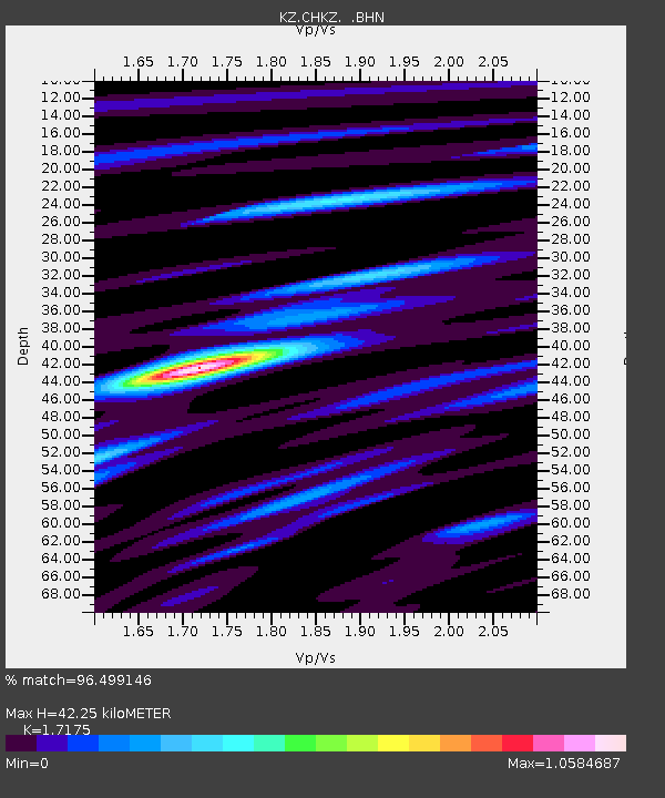
| Estimated Moho Depth: |
42.25 km |
| Estimated Crust Vp/Vs: |
1.72 |
| Assumed Crust Vp: |
6.552 km/s |
| Estimated Crust Vs: |
3.815 km/s |
| Estimated Crust Poisson's Ratio: |
0.24 |
|
| Radial Match: |
96.499146 % |
| Radial Bump: |
331 |
| Transverse Match: |
90.72375 % |
| Transverse Bump: |
400 |
| SOD ConfigId: |
20082 |
| Insert Time: |
2010-03-09 09:02:57.370 +0000 |
| GWidth: |
2.5 |
| Max Bumps: |
400 |
| Tol: |
0.001 |
|

Signal To Noise
| Channel | StoN | STA | LTA |
| KZ:CHKZ: :BHN:20011012T15:12:57.556003Z | 3.098744 | 1.4532497E-8 | 4.6898023E-9 |
| KZ:CHKZ: :BHE:20011012T15:12:57.556003Z | 50.121105 | 1.9094475E-7 | 3.8096677E-9 |
| KZ:CHKZ: :BHZ:20011012T15:12:57.556003Z | 78.75782 | 4.7672913E-7 | 6.053102E-9 |
| Arrivals |
| Ps | 4.8 SECOND |
| PpPs | 17 SECOND |
| PsPs/PpSs | 22 SECOND |


