You are here: Home > Network List > CI - Caltech Regional Seismic Network Stations List
> Station MPP McPhearson Peak > Earthquake Result Viewer
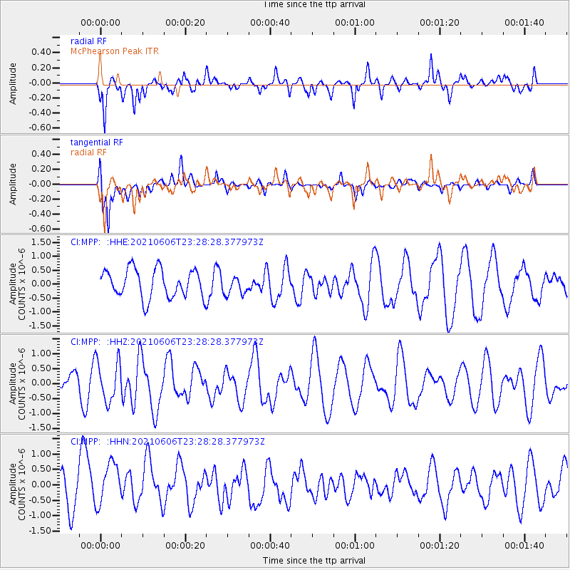
MPP McPhearson Peak - Earthquake Result Viewer
*The percent match for this event was below the threshold and hence no stack was calculated.
| Earthquake location: |
Kermadec Islands Region |
| Earthquake latitude/longitude: |
-27.7/-176.3 |
| Earthquake time(UTC): |
2021/06/06 (157) 23:16:39 GMT |
| Earthquake Depth: |
10 km |
| Earthquake Magnitude: |
5.8 mww |
| Earthquake Catalog/Contributor: |
NEIC PDE/us |
|
| Network: |
CI Caltech Regional Seismic Network |
| Station: |
MPP McPhearson Peak |
| Lat/Lon: |
34.89 N/119.81 W |
| Elevation: |
1739 m |
|
| Distance: |
82.0 deg |
| Az: |
43.801 deg |
| Baz: |
228.309 deg |
| Ray Param: |
$rayparam |
*The percent match for this event was below the threshold and hence was not used in the summary stack. |
|
| Radial Match: |
64.58932 % |
| Radial Bump: |
400 |
| Transverse Match: |
54.737564 % |
| Transverse Bump: |
400 |
| SOD ConfigId: |
25131211 |
| Insert Time: |
2021-06-20 23:24:16.534 +0000 |
| GWidth: |
2.5 |
| Max Bumps: |
400 |
| Tol: |
0.001 |
|
Signal To Noise
| Channel | StoN | STA | LTA |
| CI:MPP: :HHZ:20210606T23:28:28.377973Z | 2.276087 | 6.5941936E-7 | 2.8971624E-7 |
| CI:MPP: :HHN:20210606T23:28:28.377973Z | 1.3489155 | 7.637664E-7 | 5.662078E-7 |
| CI:MPP: :HHE:20210606T23:28:28.377973Z | 0.65501046 | 3.3338614E-7 | 5.0897836E-7 |
| Arrivals |
| Ps | |
| PpPs | |
| PsPs/PpSs | |


