You are here: Home > Network List > AK - Alaska Regional Network Stations List
> Station G17K Kiwalik Mountain, AK, USA > Earthquake Result Viewer
G17K Kiwalik Mountain, AK, USA - Earthquake Result Viewer
| Earthquake location: |
New Britain Region, P.N.G. |
| Earthquake latitude/longitude: |
-5.2/151.3 |
| Earthquake time(UTC): |
2021/06/08 (159) 10:56:38 GMT |
| Earthquake Depth: |
139 km |
| Earthquake Magnitude: |
5.7 Mww |
| Earthquake Catalog/Contributor: |
NEIC PDE/us |
|
| Network: |
AK Alaska Regional Network |
| Station: |
G17K Kiwalik Mountain, AK, USA |
| Lat/Lon: |
65.50 N/160.65 W |
| Elevation: |
338 m |
|
| Distance: |
78.7 deg |
| Az: |
18.44 deg |
| Baz: |
229.07 deg |
| Ray Param: |
0.049147375 |
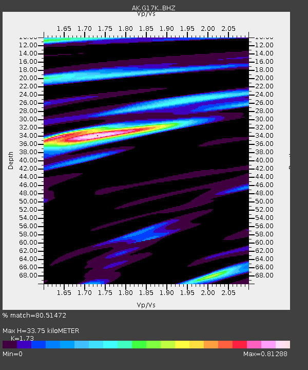
| Estimated Moho Depth: |
33.75 km |
| Estimated Crust Vp/Vs: |
1.73 |
| Assumed Crust Vp: |
6.276 km/s |
| Estimated Crust Vs: |
3.628 km/s |
| Estimated Crust Poisson's Ratio: |
0.25 |
|
| Radial Match: |
80.51472 % |
| Radial Bump: |
396 |
| Transverse Match: |
73.93674 % |
| Transverse Bump: |
380 |
| SOD ConfigId: |
25131211 |
| Insert Time: |
2021-06-22 10:58:14.007 +0000 |
| GWidth: |
2.5 |
| Max Bumps: |
400 |
| Tol: |
0.001 |
|

Signal To Noise
| Channel | StoN | STA | LTA |
| AK:G17K: :BHZ:20210608T11:07:53.919996Z | 12.136727 | 7.879859E-7 | 6.492573E-8 |
| AK:G17K: :BHN:20210608T11:07:53.919996Z | 4.0151825 | 1.6985008E-7 | 4.2301956E-8 |
| AK:G17K: :BHE:20210608T11:07:53.919996Z | 4.011419 | 2.1167772E-7 | 5.276879E-8 |
| Arrivals |
| Ps | 4.0 SECOND |
| PpPs | 14 SECOND |
| PsPs/PpSs | 18 SECOND |


