You are here: Home > Network List > AV - Alaska Volcano Observatory Stations List
> Station SPCR Ckakachatna River, Mount Spurr, Alaska > Earthquake Result Viewer
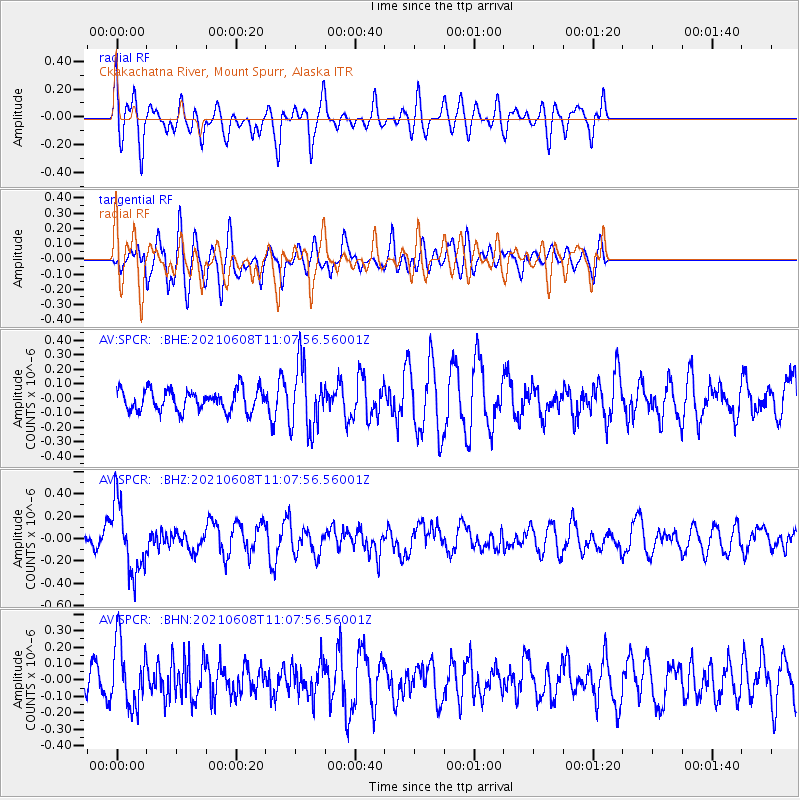
SPCR Ckakachatna River, Mount Spurr, Alaska - Earthquake Result Viewer
*The percent match for this event was below the threshold and hence no stack was calculated.
| Earthquake location: |
New Britain Region, P.N.G. |
| Earthquake latitude/longitude: |
-5.2/151.3 |
| Earthquake time(UTC): |
2021/06/08 (159) 10:56:38 GMT |
| Earthquake Depth: |
139 km |
| Earthquake Magnitude: |
5.7 Mww |
| Earthquake Catalog/Contributor: |
NEIC PDE/us |
|
| Network: |
AV Alaska Volcano Observatory |
| Station: |
SPCR Ckakachatna River, Mount Spurr, Alaska |
| Lat/Lon: |
61.20 N/152.21 W |
| Elevation: |
984 m |
|
| Distance: |
79.2 deg |
| Az: |
24.275 deg |
| Baz: |
237.735 deg |
| Ray Param: |
$rayparam |
*The percent match for this event was below the threshold and hence was not used in the summary stack. |
|
| Radial Match: |
66.171425 % |
| Radial Bump: |
400 |
| Transverse Match: |
49.43744 % |
| Transverse Bump: |
400 |
| SOD ConfigId: |
25131211 |
| Insert Time: |
2021-06-22 11:02:26.874 +0000 |
| GWidth: |
2.5 |
| Max Bumps: |
400 |
| Tol: |
0.001 |
|
Signal To Noise
| Channel | StoN | STA | LTA |
| AV:SPCR: :BHZ:20210608T11:07:56.56001Z | 4.7494197 | 3.0874202E-7 | 6.500626E-8 |
| AV:SPCR: :BHN:20210608T11:07:56.56001Z | 1.5047073 | 1.9550355E-7 | 1.2992795E-7 |
| AV:SPCR: :BHE:20210608T11:07:56.56001Z | 3.058667 | 2.2562031E-7 | 7.376426E-8 |
| Arrivals |
| Ps | |
| PpPs | |
| PsPs/PpSs | |


