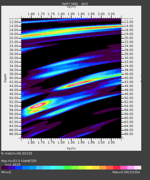
NRN XW.NRN - Earthquake Result Viewer

Earthquake location: Northwest Of Ryukyu Islands
Earthquake latitude/longitude: 28.5/127.6
Earthquake time(UTC): 1998/10/03 (276) 11:15:42 GMT
Earthquake Depth: 227 km
Earthquake Magnitude: 5.6 MB, 6.1 UNKNOWN, 6.1 MW
Earthquake Catalog/Contributor: WHDF/NEIC
Network: XW Tien Shan Continental Dynamics
Station: NRN XW.NRN
Lat/Lon: 41.42 N/75.98 E
Elevation: 2019 m
Distance: 43.6 deg
Az: 301.298 deg
Baz: 90.249 deg
Ray Param: 0.0715325
Estimated Moho Depth: 53.5 km
Estimated Crust Vp/Vs: 1.68
Assumed Crust Vp: 6.491 km/s
Estimated Crust Vs: 3.858 km/s
Estimated Crust Poisson's Ratio: 0.23
Radial Match: 80.80335 %
Radial Bump: 340
Transverse Match: 58.590946 %
Transverse Bump: 400
SOD ConfigId: 4480
Insert Time: 2010-02-26 15:39:24.621 +0000
GWidth: 2.5
Max Bumps: 400
Tol: 0.001

Signal To Noise

ChannelStoNSTALTA
XW:NRN: :BHZ:19981003T11:22:54.050012Z11.5541851.2010476E-61.03949134E-7
XW:NRN: :BHN:19981003T11:22:54.050012Z2.74903733.232195E-71.1757552E-7
XW:NRN: :BHE:19981003T11:22:54.050012Z21.0292556.7967096E-73.232026E-8
Arrivals
Ps6.0 SECOND
PpPs21 SECOND
PsPs/PpSs27 SECOND