You are here: Home > Network List > CN - Canadian National Seismograph Network Stations List
> Station INK INUVIK, NT > Earthquake Result Viewer
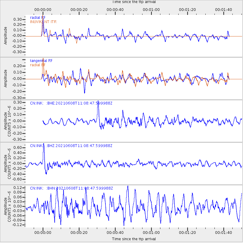
INK INUVIK, NT - Earthquake Result Viewer
*The percent match for this event was below the threshold and hence no stack was calculated.
| Earthquake location: |
New Britain Region, P.N.G. |
| Earthquake latitude/longitude: |
-5.2/151.3 |
| Earthquake time(UTC): |
2021/06/08 (159) 10:56:38 GMT |
| Earthquake Depth: |
139 km |
| Earthquake Magnitude: |
5.7 Mww |
| Earthquake Catalog/Contributor: |
NEIC PDE/us |
|
| Network: |
CN Canadian National Seismograph Network |
| Station: |
INK INUVIK, NT |
| Lat/Lon: |
68.31 N/133.53 W |
| Elevation: |
44 m |
|
| Distance: |
89.3 deg |
| Az: |
21.066 deg |
| Baz: |
254.35 deg |
| Ray Param: |
$rayparam |
*The percent match for this event was below the threshold and hence was not used in the summary stack. |
|
| Radial Match: |
57.307907 % |
| Radial Bump: |
400 |
| Transverse Match: |
70.60456 % |
| Transverse Bump: |
400 |
| SOD ConfigId: |
25131211 |
| Insert Time: |
2021-06-22 11:05:54.127 +0000 |
| GWidth: |
2.5 |
| Max Bumps: |
400 |
| Tol: |
0.001 |
|
Signal To Noise
| Channel | StoN | STA | LTA |
| CN:INK: :BHZ:20210608T11:08:47.599988Z | 5.126908 | 2.9276345E-7 | 5.7103318E-8 |
| CN:INK: :BHN:20210608T11:08:47.599988Z | 1.4237319 | 3.2862808E-8 | 2.308216E-8 |
| CN:INK: :BHE:20210608T11:08:47.599988Z | 3.929891 | 1.2048382E-7 | 3.065831E-8 |
| Arrivals |
| Ps | |
| PpPs | |
| PsPs/PpSs | |


