You are here: Home > Network List > KZ - Kazakhstan Network Stations List
> Station CHKZ Chkalovo, Kazakstan > Earthquake Result Viewer
CHKZ Chkalovo, Kazakstan - Earthquake Result Viewer
| Earthquake location: |
Bismarck Sea |
| Earthquake latitude/longitude: |
-3.4/148.6 |
| Earthquake time(UTC): |
2002/10/31 (304) 01:35:16 GMT |
| Earthquake Depth: |
10 km |
| Earthquake Magnitude: |
5.3 MB, 6.0 MS, 6.1 MW, 6.0 MW |
| Earthquake Catalog/Contributor: |
WHDF/NEIC |
|
| Network: |
KZ Kazakhstan Network |
| Station: |
CHKZ Chkalovo, Kazakstan |
| Lat/Lon: |
53.68 N/70.62 E |
| Elevation: |
120 m |
|
| Distance: |
85.7 deg |
| Az: |
324.293 deg |
| Baz: |
101.686 deg |
| Ray Param: |
0.044590503 |
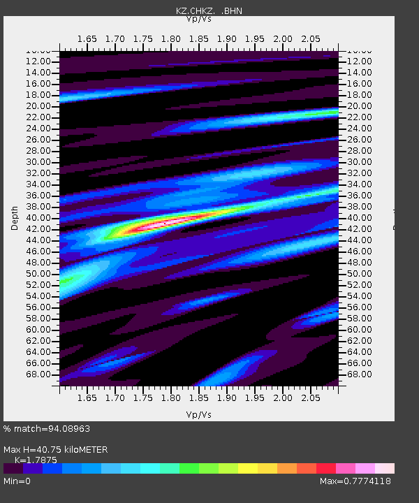
| Estimated Moho Depth: |
40.75 km |
| Estimated Crust Vp/Vs: |
1.79 |
| Assumed Crust Vp: |
6.552 km/s |
| Estimated Crust Vs: |
3.666 km/s |
| Estimated Crust Poisson's Ratio: |
0.27 |
|
| Radial Match: |
94.08963 % |
| Radial Bump: |
345 |
| Transverse Match: |
82.36249 % |
| Transverse Bump: |
400 |
| SOD ConfigId: |
4714 |
| Insert Time: |
2010-03-09 09:05:33.760 +0000 |
| GWidth: |
2.5 |
| Max Bumps: |
400 |
| Tol: |
0.001 |
|

Signal To Noise
| Channel | StoN | STA | LTA |
| KZ:CHKZ: :BHN:20021031T01:47:24.063005Z | 0.9057457 | 3.1946005E-8 | 3.5270393E-8 |
| KZ:CHKZ: :BHE:20021031T01:47:24.063005Z | 1.5771407 | 6.514331E-8 | 4.130469E-8 |
| KZ:CHKZ: :BHZ:20021031T01:47:24.063005Z | 1.7295885 | 9.23339E-8 | 5.338489E-8 |
| Arrivals |
| Ps | 5.0 SECOND |
| PpPs | 17 SECOND |
| PsPs/PpSs | 22 SECOND |


