You are here: Home > Network List > MM - Myanmar National Seismic Network Stations List
> Station TMU Tamu, Sagaing, Myanmar > Earthquake Result Viewer
TMU Tamu, Sagaing, Myanmar - Earthquake Result Viewer
| Earthquake location: |
New Britain Region, P.N.G. |
| Earthquake latitude/longitude: |
-5.2/151.3 |
| Earthquake time(UTC): |
2021/06/08 (159) 10:56:38 GMT |
| Earthquake Depth: |
139 km |
| Earthquake Magnitude: |
5.7 Mww |
| Earthquake Catalog/Contributor: |
NEIC PDE/us |
|
| Network: |
MM Myanmar National Seismic Network |
| Station: |
TMU Tamu, Sagaing, Myanmar |
| Lat/Lon: |
24.23 N/94.30 E |
| Elevation: |
182 m |
|
| Distance: |
62.7 deg |
| Az: |
300.503 deg |
| Baz: |
109.951 deg |
| Ray Param: |
0.05966562 |
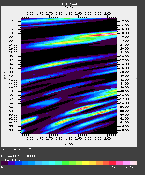
| Estimated Moho Depth: |
18.0 km |
| Estimated Crust Vp/Vs: |
2.10 |
| Assumed Crust Vp: |
6.316 km/s |
| Estimated Crust Vs: |
3.011 km/s |
| Estimated Crust Poisson's Ratio: |
0.35 |
|
| Radial Match: |
82.67272 % |
| Radial Bump: |
400 |
| Transverse Match: |
70.6267 % |
| Transverse Bump: |
400 |
| SOD ConfigId: |
25131211 |
| Insert Time: |
2021-06-22 11:08:54.352 +0000 |
| GWidth: |
2.5 |
| Max Bumps: |
400 |
| Tol: |
0.001 |
|

Signal To Noise
| Channel | StoN | STA | LTA |
| MM:TMU: :HHZ:20210608T11:06:17.417981Z | 7.115151 | 5.4175257E-7 | 7.61407E-8 |
| MM:TMU: :HHN:20210608T11:06:17.417981Z | 3.6013045 | 1.8944742E-7 | 5.260522E-8 |
| MM:TMU: :HHE:20210608T11:06:17.417981Z | 5.8900766 | 4.513735E-7 | 7.663287E-8 |
| Arrivals |
| Ps | 3.2 SECOND |
| PpPs | 8.5 SECOND |
| PsPs/PpSs | 12 SECOND |


