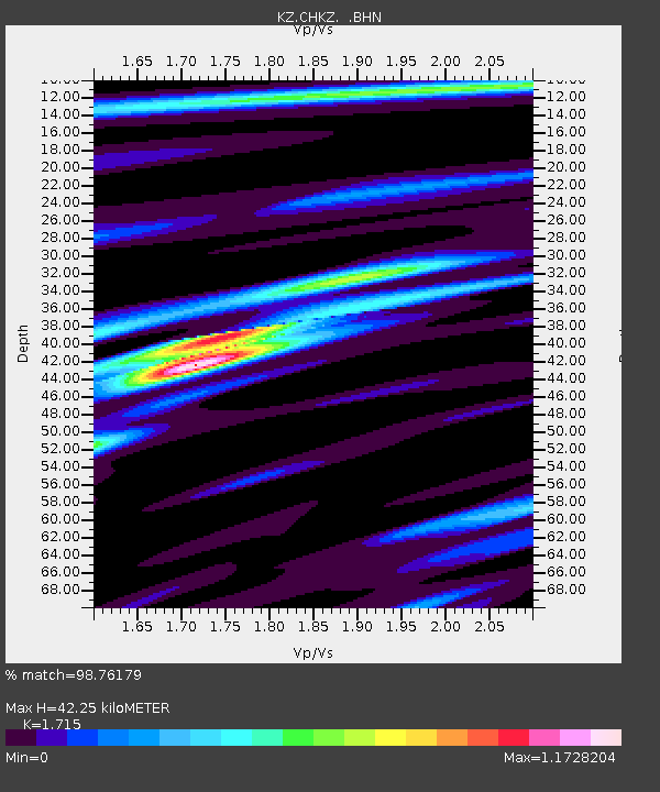
CHKZ Chkalovo, Kazakstan - Earthquake Result Viewer

Earthquake location: Rat Islands, Aleutian Islands
Earthquake latitude/longitude: 51.6/176.9
Earthquake time(UTC): 2003/06/15 (166) 19:24:33 GMT
Earthquake Depth: 20 km
Earthquake Magnitude: 6.0 MB, 6.4 MS, 6.5 MW, 6.5 MW
Earthquake Catalog/Contributor: WHDF/NEIC
Network: KZ Kazakhstan Network
Station: CHKZ Chkalovo, Kazakstan
Lat/Lon: 53.68 N/70.62 E
Elevation: 120 m
Distance: 58.4 deg
Az: 317.918 deg
Baz: 44.696 deg
Ray Param: 0.06282723
Estimated Moho Depth: 42.25 km
Estimated Crust Vp/Vs: 1.72
Assumed Crust Vp: 6.552 km/s
Estimated Crust Vs: 3.821 km/s
Estimated Crust Poisson's Ratio: 0.24
Radial Match: 98.76179 %
Radial Bump: 295
Transverse Match: 91.253845 %
Transverse Bump: 400
SOD ConfigId: 4714
Insert Time: 2010-03-09 09:06:07.319 +0000
GWidth: 2.5
Max Bumps: 400
Tol: 0.001

Signal To Noise

ChannelStoNSTALTA
KZ:CHKZ: :BHN:20030615T19:33:56.365027Z41.2152829.25668E-72.245934E-8
KZ:CHKZ: :BHE:20030615T19:33:56.363013Z47.7797249.486413E-71.9854474E-8
KZ:CHKZ: :BHZ:20030615T19:33:56.363013Z60.678452.6178072E-64.314229E-8
Arrivals
Ps4.9 SECOND
PpPs17 SECOND
PsPs/PpSs21 SECOND