You are here: Home > Network List > KZ - Kazakhstan Network Stations List
> Station KKAR Karatau array,KK31, Kazakhstan > Earthquake Result Viewer
KKAR Karatau array,KK31, Kazakhstan - Earthquake Result Viewer
| Earthquake location: |
Bonin Islands, Japan Region |
| Earthquake latitude/longitude: |
26.8/140.6 |
| Earthquake time(UTC): |
2005/12/26 (360) 13:48:01 GMT |
| Earthquake Depth: |
7.4 km |
| Earthquake Magnitude: |
5.8 MB, 5.3 MS, 5.7 MW, 5.5 MW |
| Earthquake Catalog/Contributor: |
WHDF/NEIC |
|
| Network: |
KZ Kazakhstan Network |
| Station: |
KKAR Karatau array,KK31, Kazakhstan |
| Lat/Lon: |
43.11 N/70.51 E |
| Elevation: |
525 m |
|
| Distance: |
58.1 deg |
| Az: |
305.8 deg |
| Baz: |
81.742 deg |
| Ray Param: |
0.06304885 |
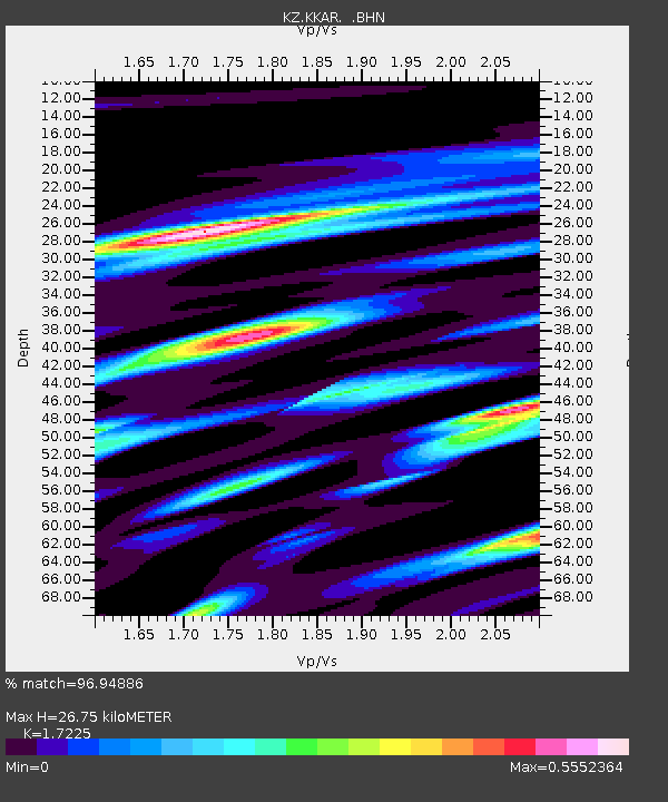
| Estimated Moho Depth: |
26.75 km |
| Estimated Crust Vp/Vs: |
1.72 |
| Assumed Crust Vp: |
6.316 km/s |
| Estimated Crust Vs: |
3.667 km/s |
| Estimated Crust Poisson's Ratio: |
0.25 |
|
| Radial Match: |
96.94886 % |
| Radial Bump: |
364 |
| Transverse Match: |
89.43965 % |
| Transverse Bump: |
400 |
| SOD ConfigId: |
2422 |
| Insert Time: |
2010-03-09 09:07:45.284 +0000 |
| GWidth: |
2.5 |
| Max Bumps: |
400 |
| Tol: |
0.001 |
|

Signal To Noise
| Channel | StoN | STA | LTA |
| KZ:KKAR: :BHN:20051226T13:57:24.799011Z | 12.37955 | 7.858394E-7 | 6.3478836E-8 |
| KZ:KKAR: :BHE:20051226T13:57:24.799011Z | 28.274765 | 2.2053448E-6 | 7.799693E-8 |
| KZ:KKAR: :BHZ:20051226T13:57:24.799011Z | 64.37389 | 4.7224926E-6 | 7.336037E-8 |
| Arrivals |
| Ps | 3.2 SECOND |
| PpPs | 11 SECOND |
| PsPs/PpSs | 14 SECOND |


