You are here: Home > Network List > US - United States National Seismic Network Stations List
> Station CBKS Cedar Bluff, Kansas, USA > Earthquake Result Viewer
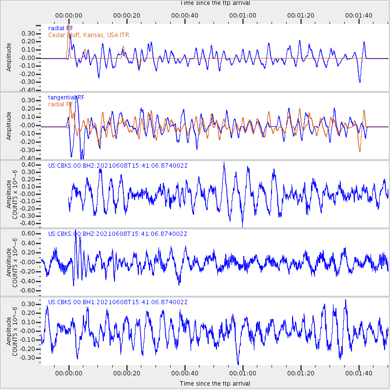
CBKS Cedar Bluff, Kansas, USA - Earthquake Result Viewer
*The percent match for this event was below the threshold and hence no stack was calculated.
| Earthquake location: |
Off East Coast Of Honshu, Japan |
| Earthquake latitude/longitude: |
36.4/143.1 |
| Earthquake time(UTC): |
2021/06/08 (159) 15:29:01 GMT |
| Earthquake Depth: |
10 km |
| Earthquake Magnitude: |
5.3 Mww |
| Earthquake Catalog/Contributor: |
NEIC PDE/us |
|
| Network: |
US United States National Seismic Network |
| Station: |
CBKS Cedar Bluff, Kansas, USA |
| Lat/Lon: |
38.81 N/99.74 W |
| Elevation: |
677 m |
|
| Distance: |
85.4 deg |
| Az: |
44.195 deg |
| Baz: |
313.958 deg |
| Ray Param: |
$rayparam |
*The percent match for this event was below the threshold and hence was not used in the summary stack. |
|
| Radial Match: |
47.99346 % |
| Radial Bump: |
400 |
| Transverse Match: |
75.50915 % |
| Transverse Bump: |
400 |
| SOD ConfigId: |
25131211 |
| Insert Time: |
2021-06-22 15:50:15.413 +0000 |
| GWidth: |
2.5 |
| Max Bumps: |
400 |
| Tol: |
0.001 |
|
Signal To Noise
| Channel | StoN | STA | LTA |
| US:CBKS:00:BHZ:20210608T15:41:06.874002Z | 2.331055 | 2.7660022E-7 | 1.1865882E-7 |
| US:CBKS:00:BH1:20210608T15:41:06.874002Z | 0.85191506 | 1.1922667E-7 | 1.3995135E-7 |
| US:CBKS:00:BH2:20210608T15:41:06.874002Z | 0.54048544 | 7.862352E-8 | 1.4546835E-7 |
| Arrivals |
| Ps | |
| PpPs | |
| PsPs/PpSs | |


