You are here: Home > Network List > PF - Volcanologic Network of Piton de Fournaise-OVPF Stations List
> Station HIM cratere Himiltrude > Earthquake Result Viewer
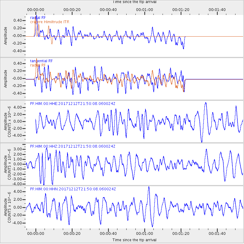
HIM cratere Himiltrude - Earthquake Result Viewer
*The percent match for this event was below the threshold and hence no stack was calculated.
| Earthquake location: |
Northern And Central Iran |
| Earthquake latitude/longitude: |
30.8/57.3 |
| Earthquake time(UTC): |
2017/12/12 (346) 21:41:31 GMT |
| Earthquake Depth: |
8.0 km |
| Earthquake Magnitude: |
6.0 Mww |
| Earthquake Catalog/Contributor: |
NEIC PDE/us |
|
| Network: |
PF Volcanologic Network of Piton de Fournaise-OVPF |
| Station: |
HIM cratere Himiltrude |
| Lat/Lon: |
21.21 S/55.72 E |
| Elevation: |
1958 m |
|
| Distance: |
51.8 deg |
| Az: |
181.86 deg |
| Baz: |
1.715 deg |
| Ray Param: |
$rayparam |
*The percent match for this event was below the threshold and hence was not used in the summary stack. |
|
| Radial Match: |
49.226524 % |
| Radial Bump: |
368 |
| Transverse Match: |
68.36433 % |
| Transverse Bump: |
400 |
| SOD ConfigId: |
2429771 |
| Insert Time: |
2017-12-26 21:43:40.053 +0000 |
| GWidth: |
2.5 |
| Max Bumps: |
400 |
| Tol: |
0.001 |
|
Signal To Noise
| Channel | StoN | STA | LTA |
| PF:HIM:00:HHZ:20171212T21:50:08.060024Z | 3.3602476 | 2.1869964E-6 | 6.5084384E-7 |
| PF:HIM:00:HHN:20171212T21:50:08.060024Z | 0.68516946 | 7.0544456E-7 | 1.0295913E-6 |
| PF:HIM:00:HHE:20171212T21:50:08.060024Z | 1.0491267 | 1.5673114E-6 | 1.49392E-6 |
| Arrivals |
| Ps | |
| PpPs | |
| PsPs/PpSs | |


