You are here: Home > Network List > PF - Volcanologic Network of Piton de Fournaise-OVPF Stations List
> Station HIM cratere Himiltrude > Earthquake Result Viewer
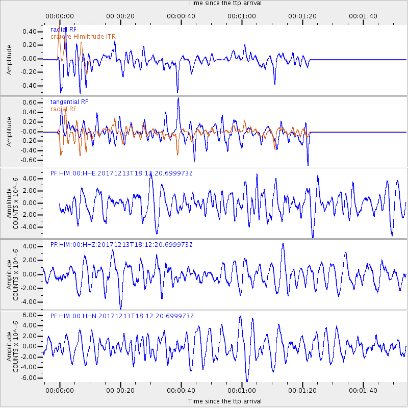
HIM cratere Himiltrude - Earthquake Result Viewer
*The percent match for this event was below the threshold and hence no stack was calculated.
| Earthquake location: |
Bouvet Island Region |
| Earthquake latitude/longitude: |
-54.2/2.1 |
| Earthquake time(UTC): |
2017/12/13 (347) 18:03:42 GMT |
| Earthquake Depth: |
10 km |
| Earthquake Magnitude: |
6.5 mww |
| Earthquake Catalog/Contributor: |
NEIC PDE/us |
|
| Network: |
PF Volcanologic Network of Piton de Fournaise-OVPF |
| Station: |
HIM cratere Himiltrude |
| Lat/Lon: |
21.21 S/55.72 E |
| Elevation: |
1958 m |
|
| Distance: |
51.9 deg |
| Az: |
72.467 deg |
| Baz: |
216.885 deg |
| Ray Param: |
$rayparam |
*The percent match for this event was below the threshold and hence was not used in the summary stack. |
|
| Radial Match: |
58.192486 % |
| Radial Bump: |
400 |
| Transverse Match: |
61.494267 % |
| Transverse Bump: |
400 |
| SOD ConfigId: |
2429771 |
| Insert Time: |
2017-12-27 18:05:14.233 +0000 |
| GWidth: |
2.5 |
| Max Bumps: |
400 |
| Tol: |
0.001 |
|
Signal To Noise
| Channel | StoN | STA | LTA |
| PF:HIM:00:HHZ:20171213T18:12:20.699973Z | 0.9015856 | 6.0607033E-7 | 6.722272E-7 |
| PF:HIM:00:HHN:20171213T18:12:20.699973Z | 0.8703755 | 1.5894449E-6 | 1.82616E-6 |
| PF:HIM:00:HHE:20171213T18:12:20.699973Z | 2.228055 | 3.1746313E-6 | 1.4248443E-6 |
| Arrivals |
| Ps | |
| PpPs | |
| PsPs/PpSs | |


