You are here: Home > Network List > G - GEOSCOPE Stations List
> Station NOUC Port Laguerre, New Caledonia > Earthquake Result Viewer
NOUC Port Laguerre, New Caledonia - Earthquake Result Viewer
| Earthquake location: |
Java, Indonesia |
| Earthquake latitude/longitude: |
-7.7/108.0 |
| Earthquake time(UTC): |
2017/12/15 (349) 16:47:56 GMT |
| Earthquake Depth: |
92 km |
| Earthquake Magnitude: |
6.5 Mww |
| Earthquake Catalog/Contributor: |
NEIC PDE/us |
|
| Network: |
G GEOSCOPE |
| Station: |
NOUC Port Laguerre, New Caledonia |
| Lat/Lon: |
22.10 S/166.30 E |
| Elevation: |
112 m |
|
| Distance: |
57.8 deg |
| Az: |
111.171 deg |
| Baz: |
274.809 deg |
| Ray Param: |
0.063012384 |
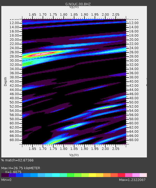
| Estimated Moho Depth: |
26.75 km |
| Estimated Crust Vp/Vs: |
1.69 |
| Assumed Crust Vp: |
5.14 km/s |
| Estimated Crust Vs: |
3.046 km/s |
| Estimated Crust Poisson's Ratio: |
0.23 |
|
| Radial Match: |
82.67366 % |
| Radial Bump: |
400 |
| Transverse Match: |
84.465546 % |
| Transverse Bump: |
400 |
| SOD ConfigId: |
2429771 |
| Insert Time: |
2017-12-29 16:48:24.289 +0000 |
| GWidth: |
2.5 |
| Max Bumps: |
400 |
| Tol: |
0.001 |
|

Signal To Noise
| Channel | StoN | STA | LTA |
| G:NOUC:00:BHZ:20171215T16:57:07.899971Z | 4.617115 | 1.6366879E-6 | 3.5448284E-7 |
| G:NOUC:00:BHN:20171215T16:57:07.899971Z | 1.3280572 | 2.4268172E-7 | 1.8273438E-7 |
| G:NOUC:00:BHE:20171215T16:57:07.899971Z | 4.222151 | 7.4440794E-7 | 1.7631012E-7 |
| Arrivals |
| Ps | 3.7 SECOND |
| PpPs | 14 SECOND |
| PsPs/PpSs | 17 SECOND |


