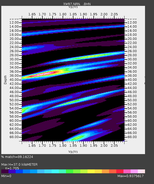
NRN XW.NRN - Earthquake Result Viewer
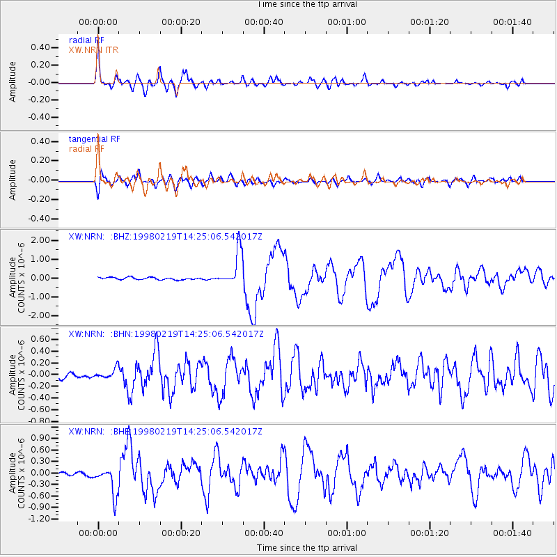
Earthquake location: Banda Sea
Earthquake latitude/longitude: -4.5/129.1
Earthquake time(UTC): 1998/02/19 (050) 14:14:51 GMT
Earthquake Depth: 33 km
Earthquake Magnitude: 6.1 MB, 6.4 MS, 6.5 UNKNOWN, 6.5 MW
Earthquake Catalog/Contributor: WHDF/NEIC
Network: XW Tien Shan Continental Dynamics
Station: NRN XW.NRN
Lat/Lon: 41.42 N/75.98 E
Elevation: 2019 m
Distance: 66.5 deg
Az: 319.011 deg
Baz: 119.594 deg
Ray Param: 0.05753566
Estimated Moho Depth: 37.0 km
Estimated Crust Vp/Vs: 1.71
Assumed Crust Vp: 6.491 km/s
Estimated Crust Vs: 3.807 km/s
Estimated Crust Poisson's Ratio: 0.24
Radial Match: 89.16224 %
Radial Bump: 400
Transverse Match: 76.42395 %
Transverse Bump: 400
SOD ConfigId: 6273
Insert Time: 2010-02-26 15:39:53.141 +0000
GWidth: 2.5
Max Bumps: 400
Tol: 0.001

Signal To Noise

ChannelStoNSTALTA
XW:NRN: :BHN:19980219T14:25:06.542017Z1.68461548.939349E-85.306463E-8
XW:NRN: :BHE:19980219T14:25:06.542017Z7.6089613.9424916E-75.1813796E-8
XW:NRN: :BHZ:19980219T14:25:06.542017Z16.828359.915327E-75.8920378E-8
Arrivals
Ps4.2 SECOND
PpPs15 SECOND
PsPs/PpSs19 SECOND