You are here: Home > Network List > KZ - Kazakhstan Network Stations List
> Station KKAR Karatau array,KK31, Kazakhstan > Earthquake Result Viewer
KKAR Karatau array,KK31, Kazakhstan - Earthquake Result Viewer
| Earthquake location: |
Ryukyu Islands, Japan |
| Earthquake latitude/longitude: |
29.2/129.8 |
| Earthquake time(UTC): |
2009/10/30 (303) 07:03:39 GMT |
| Earthquake Depth: |
34 km |
| Earthquake Magnitude: |
6.3 MB, 6.8 MS, 6.8 MW, 6.8 MW |
| Earthquake Catalog/Contributor: |
WHDF/NEIC |
|
| Network: |
KZ Kazakhstan Network |
| Station: |
KKAR Karatau array,KK31, Kazakhstan |
| Lat/Lon: |
43.11 N/70.51 E |
| Elevation: |
525 m |
|
| Distance: |
48.9 deg |
| Az: |
303.295 deg |
| Baz: |
86.074 deg |
| Ray Param: |
0.06900398 |
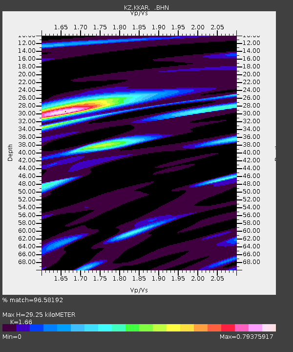
| Estimated Moho Depth: |
29.25 km |
| Estimated Crust Vp/Vs: |
1.66 |
| Assumed Crust Vp: |
6.316 km/s |
| Estimated Crust Vs: |
3.805 km/s |
| Estimated Crust Poisson's Ratio: |
0.22 |
|
| Radial Match: |
96.58192 % |
| Radial Bump: |
284 |
| Transverse Match: |
83.588 % |
| Transverse Bump: |
400 |
| SOD ConfigId: |
2622 |
| Insert Time: |
2010-03-09 09:13:54.017 +0000 |
| GWidth: |
2.5 |
| Max Bumps: |
400 |
| Tol: |
0.001 |
|

Signal To Noise
| Channel | StoN | STA | LTA |
| KZ:KKAR: :BHN:20091030T07:11:50.898992Z | 20.293753 | 1.8099221E-6 | 8.918617E-8 |
| KZ:KKAR: :BHE:20091030T07:11:50.898992Z | 4.2331247 | 1.8642399E-7 | 4.4039332E-8 |
| KZ:KKAR: :BHZ:20091030T07:11:50.898992Z | 14.28803 | 9.669646E-7 | 6.767656E-8 |
| Arrivals |
| Ps | 3.3 SECOND |
| PpPs | 12 SECOND |
| PsPs/PpSs | 15 SECOND |


