You are here: Home > Network List > PF - Volcanologic Network of Piton de Fournaise-OVPF Stations List
> Station GPS Grandes Pentes Sud > Earthquake Result Viewer
GPS Grandes Pentes Sud - Earthquake Result Viewer
*The percent match for this event was below the threshold and hence no stack was calculated.
| Earthquake location: |
Java, Indonesia |
| Earthquake latitude/longitude: |
-7.7/108.0 |
| Earthquake time(UTC): |
2017/12/15 (349) 16:47:56 GMT |
| Earthquake Depth: |
92 km |
| Earthquake Magnitude: |
6.5 Mww |
| Earthquake Catalog/Contributor: |
NEIC PDE/us |
|
| Network: |
PF Volcanologic Network of Piton de Fournaise-OVPF |
| Station: |
GPS Grandes Pentes Sud |
| Lat/Lon: |
21.27 S/55.76 E |
| Elevation: |
1004 m |
|
| Distance: |
52.1 deg |
| Az: |
249.142 deg |
| Baz: |
83.158 deg |
| Ray Param: |
$rayparam |
*The percent match for this event was below the threshold and hence was not used in the summary stack. |
|
| Radial Match: |
74.58245 % |
| Radial Bump: |
400 |
| Transverse Match: |
61.30118 % |
| Transverse Bump: |
400 |
| SOD ConfigId: |
2429771 |
| Insert Time: |
2017-12-29 16:50:13.205 +0000 |
| GWidth: |
2.5 |
| Max Bumps: |
400 |
| Tol: |
0.001 |
|
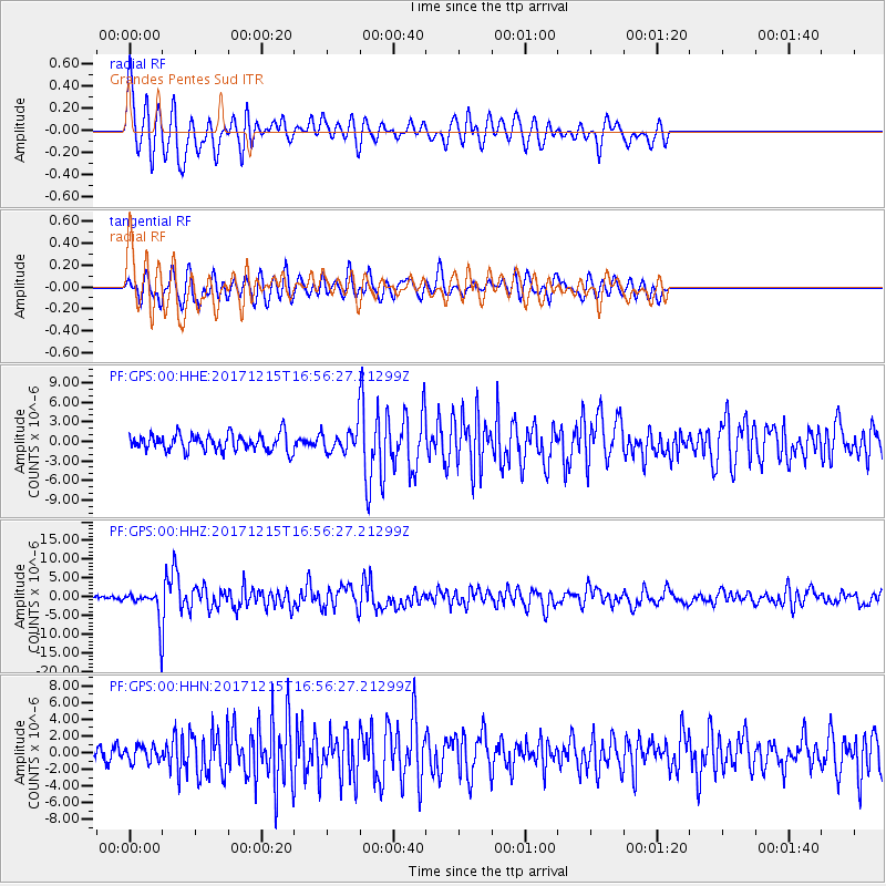
Signal To Noise
| Channel | StoN | STA | LTA |
| PF:GPS:00:HHZ:20171215T16:56:27.21299Z | 4.8407636 | 3.5337036E-6 | 7.2998887E-7 |
| PF:GPS:00:HHN:20171215T16:56:27.21299Z | 0.8253386 | 9.5006675E-7 | 1.1511236E-6 |
| PF:GPS:00:HHE:20171215T16:56:27.21299Z | 1.3258867 | 1.6642687E-6 | 1.2552118E-6 |
| Arrivals |
| Ps | |
| PpPs | |
| PsPs/PpSs | |


