You are here: Home > Network List > AZ - ANZA Regional Network Stations List
> Station SMER AZ.SMER > Earthquake Result Viewer
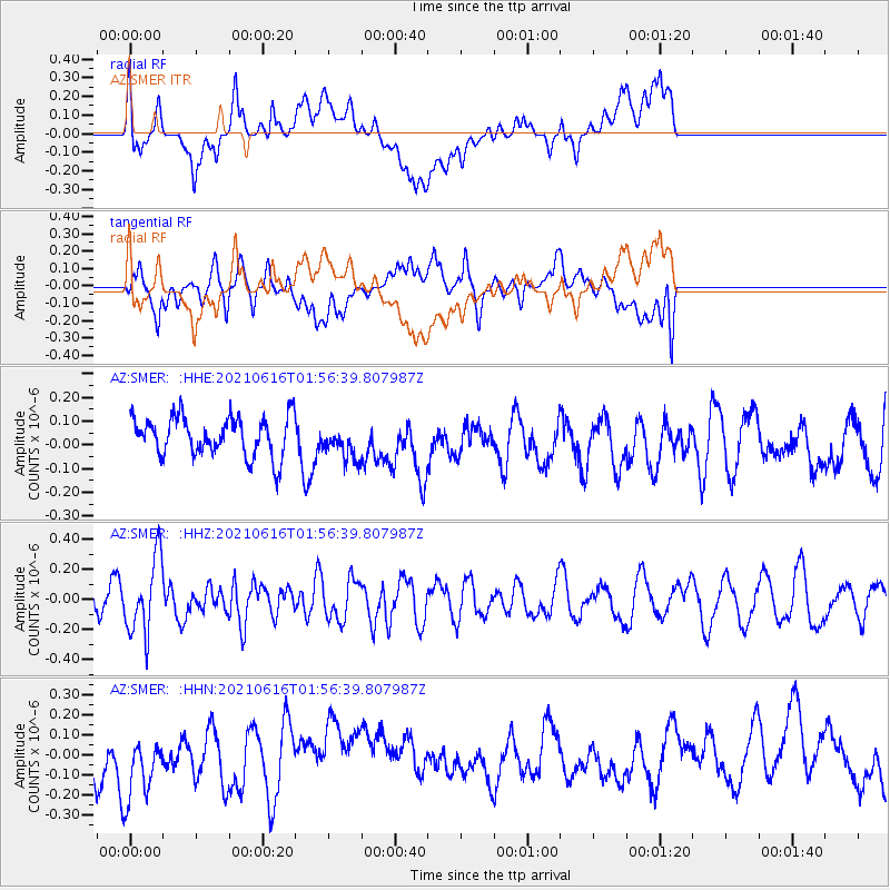
SMER AZ.SMER - Earthquake Result Viewer
*The percent match for this event was below the threshold and hence no stack was calculated.
| Earthquake location: |
Kermadec Islands Region |
| Earthquake latitude/longitude: |
-31.6/-177.2 |
| Earthquake time(UTC): |
2021/06/16 (167) 01:44:30 GMT |
| Earthquake Depth: |
8.8 km |
| Earthquake Magnitude: |
5.3 Mww |
| Earthquake Catalog/Contributor: |
NEIC PDE/us |
|
| Network: |
AZ ANZA Regional Network |
| Station: |
SMER AZ.SMER |
| Lat/Lon: |
33.46 N/117.17 W |
| Elevation: |
355 m |
|
| Distance: |
86.0 deg |
| Az: |
46.527 deg |
| Baz: |
227.768 deg |
| Ray Param: |
$rayparam |
*The percent match for this event was below the threshold and hence was not used in the summary stack. |
|
| Radial Match: |
56.292862 % |
| Radial Bump: |
400 |
| Transverse Match: |
41.54856 % |
| Transverse Bump: |
400 |
| SOD ConfigId: |
25131211 |
| Insert Time: |
2021-06-30 01:47:21.158 +0000 |
| GWidth: |
2.5 |
| Max Bumps: |
400 |
| Tol: |
0.001 |
|
Signal To Noise
| Channel | StoN | STA | LTA |
| AZ:SMER: :HHZ:20210616T01:56:39.807987Z | 3.926471 | 2.4991715E-7 | 6.364931E-8 |
| AZ:SMER: :HHN:20210616T01:56:39.807987Z | 1.1972576 | 1.6049634E-7 | 1.3405331E-7 |
| AZ:SMER: :HHE:20210616T01:56:39.807987Z | 0.8546211 | 7.043058E-8 | 8.2411475E-8 |
| Arrivals |
| Ps | |
| PpPs | |
| PsPs/PpSs | |


