You are here: Home > Network List > IU - Global Seismograph Network (GSN - IRIS/USGS) Stations List
> Station JOHN Johnston Island, USA > Earthquake Result Viewer
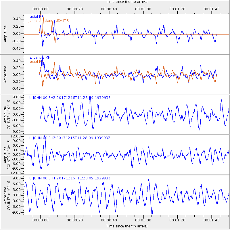
JOHN Johnston Island, USA - Earthquake Result Viewer
*The percent match for this event was below the threshold and hence no stack was calculated.
| Earthquake location: |
Fiji Islands Region |
| Earthquake latitude/longitude: |
-17.3/-177.5 |
| Earthquake time(UTC): |
2017/12/16 (350) 11:22:24 GMT |
| Earthquake Depth: |
391 km |
| Earthquake Magnitude: |
5.5 Mww |
| Earthquake Catalog/Contributor: |
NEIC PDE/us |
|
| Network: |
IU Global Seismograph Network (GSN - IRIS/USGS) |
| Station: |
JOHN Johnston Island, USA |
| Lat/Lon: |
16.73 N/169.53 W |
| Elevation: |
2.0 m |
|
| Distance: |
34.8 deg |
| Az: |
13.541 deg |
| Baz: |
193.497 deg |
| Ray Param: |
$rayparam |
*The percent match for this event was below the threshold and hence was not used in the summary stack. |
|
| Radial Match: |
46.876762 % |
| Radial Bump: |
400 |
| Transverse Match: |
70.65944 % |
| Transverse Bump: |
400 |
| SOD ConfigId: |
2429771 |
| Insert Time: |
2017-12-30 11:23:57.698 +0000 |
| GWidth: |
2.5 |
| Max Bumps: |
400 |
| Tol: |
0.001 |
|
Signal To Noise
| Channel | StoN | STA | LTA |
| IU:JOHN:00:BHZ:20171216T11:28:09.193993Z | 1.7130221 | 6.9813555E-6 | 4.0754617E-6 |
| IU:JOHN:00:BH1:20171216T11:28:09.193993Z | 0.63312143 | 3.1336551E-6 | 4.949533E-6 |
| IU:JOHN:00:BH2:20171216T11:28:09.193993Z | 1.2557557 | 4.7155104E-6 | 3.7551176E-6 |
| Arrivals |
| Ps | |
| PpPs | |
| PsPs/PpSs | |


