You are here: Home > Network List > CN - Canadian National Seismograph Network Stations List
> Station INK INUVIK, NT > Earthquake Result Viewer
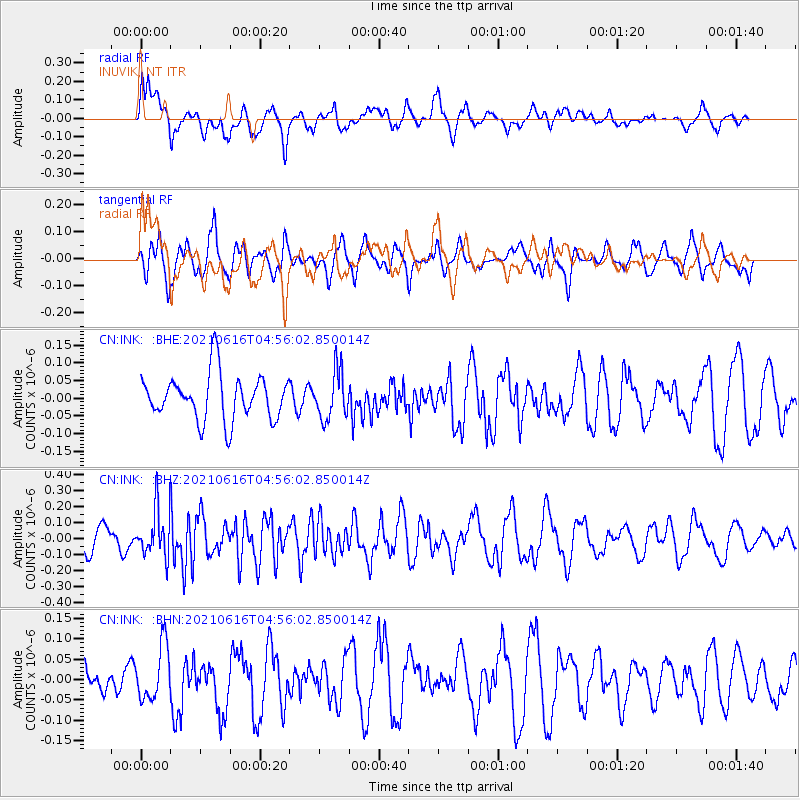
INK INUVIK, NT - Earthquake Result Viewer
*The percent match for this event was below the threshold and hence no stack was calculated.
| Earthquake location: |
Seram, Indonesia |
| Earthquake latitude/longitude: |
-3.6/129.5 |
| Earthquake time(UTC): |
2021/06/16 (167) 04:43:07 GMT |
| Earthquake Depth: |
5.7 km |
| Earthquake Magnitude: |
5.9 Mww |
| Earthquake Catalog/Contributor: |
NEIC PDE/us |
|
| Network: |
CN Canadian National Seismograph Network |
| Station: |
INK INUVIK, NT |
| Lat/Lon: |
68.31 N/133.53 W |
| Elevation: |
44 m |
|
| Distance: |
95.9 deg |
| Az: |
21.778 deg |
| Baz: |
275.135 deg |
| Ray Param: |
$rayparam |
*The percent match for this event was below the threshold and hence was not used in the summary stack. |
|
| Radial Match: |
69.8406 % |
| Radial Bump: |
400 |
| Transverse Match: |
47.729298 % |
| Transverse Bump: |
330 |
| SOD ConfigId: |
25131211 |
| Insert Time: |
2021-06-30 04:48:39.460 +0000 |
| GWidth: |
2.5 |
| Max Bumps: |
400 |
| Tol: |
0.001 |
|
Signal To Noise
| Channel | StoN | STA | LTA |
| CN:INK: :BHZ:20210616T04:56:02.850014Z | 2.27254 | 1.4626666E-7 | 6.436263E-8 |
| CN:INK: :BHN:20210616T04:56:02.850014Z | 1.3847002 | 6.731459E-8 | 4.8613114E-8 |
| CN:INK: :BHE:20210616T04:56:02.850014Z | 1.0612942 | 6.7939276E-8 | 6.4015495E-8 |
| Arrivals |
| Ps | |
| PpPs | |
| PsPs/PpSs | |


