You are here: Home > Network List > G - GEOSCOPE Stations List
> Station INU Inuyama, Japan > Earthquake Result Viewer
INU Inuyama, Japan - Earthquake Result Viewer
| Earthquake location: |
Seram, Indonesia |
| Earthquake latitude/longitude: |
-3.6/129.5 |
| Earthquake time(UTC): |
2021/06/16 (167) 04:43:07 GMT |
| Earthquake Depth: |
5.7 km |
| Earthquake Magnitude: |
5.9 Mww |
| Earthquake Catalog/Contributor: |
NEIC PDE/us |
|
| Network: |
G GEOSCOPE |
| Station: |
INU Inuyama, Japan |
| Lat/Lon: |
35.35 N/137.03 E |
| Elevation: |
132 m |
|
| Distance: |
39.3 deg |
| Az: |
9.684 deg |
| Baz: |
191.852 deg |
| Ray Param: |
0.07506735 |
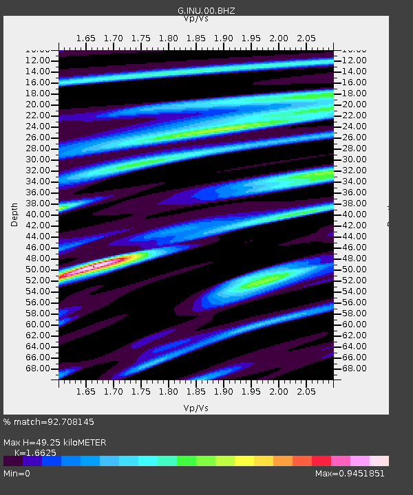
| Estimated Moho Depth: |
49.25 km |
| Estimated Crust Vp/Vs: |
1.66 |
| Assumed Crust Vp: |
6.461 km/s |
| Estimated Crust Vs: |
3.887 km/s |
| Estimated Crust Poisson's Ratio: |
0.22 |
|
| Radial Match: |
92.708145 % |
| Radial Bump: |
400 |
| Transverse Match: |
84.28858 % |
| Transverse Bump: |
400 |
| SOD ConfigId: |
25131211 |
| Insert Time: |
2021-06-30 04:48:59.231 +0000 |
| GWidth: |
2.5 |
| Max Bumps: |
400 |
| Tol: |
0.001 |
|

Signal To Noise
| Channel | StoN | STA | LTA |
| G:INU:00:BHZ:20210616T04:50:06.410988Z | 12.393826 | 1.1095735E-6 | 8.952632E-8 |
| G:INU:00:BHN:20210616T04:50:06.410988Z | 6.52383 | 6.7271833E-7 | 1.0311709E-7 |
| G:INU:00:BHE:20210616T04:50:06.410988Z | 5.5116887 | 3.5345607E-7 | 6.412845E-8 |
| Arrivals |
| Ps | 5.5 SECOND |
| PpPs | 19 SECOND |
| PsPs/PpSs | 24 SECOND |


