You are here: Home > Network List > IU - Global Seismograph Network (GSN - IRIS/USGS) Stations List
> Station ULN Ulaanbaatar, Mongolia > Earthquake Result Viewer
ULN Ulaanbaatar, Mongolia - Earthquake Result Viewer
| Earthquake location: |
Seram, Indonesia |
| Earthquake latitude/longitude: |
-3.6/129.5 |
| Earthquake time(UTC): |
2021/06/16 (167) 04:43:07 GMT |
| Earthquake Depth: |
5.7 km |
| Earthquake Magnitude: |
5.9 Mww |
| Earthquake Catalog/Contributor: |
NEIC PDE/us |
|
| Network: |
IU Global Seismograph Network (GSN - IRIS/USGS) |
| Station: |
ULN Ulaanbaatar, Mongolia |
| Lat/Lon: |
47.87 N/107.05 E |
| Elevation: |
1610 m |
|
| Distance: |
54.9 deg |
| Az: |
341.651 deg |
| Baz: |
152.184 deg |
| Ray Param: |
0.06518438 |
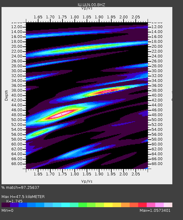
| Estimated Moho Depth: |
47.5 km |
| Estimated Crust Vp/Vs: |
1.75 |
| Assumed Crust Vp: |
6.642 km/s |
| Estimated Crust Vs: |
3.806 km/s |
| Estimated Crust Poisson's Ratio: |
0.26 |
|
| Radial Match: |
97.25637 % |
| Radial Bump: |
339 |
| Transverse Match: |
87.259995 % |
| Transverse Bump: |
400 |
| SOD ConfigId: |
25131211 |
| Insert Time: |
2021-06-30 04:50:05.903 +0000 |
| GWidth: |
2.5 |
| Max Bumps: |
400 |
| Tol: |
0.001 |
|
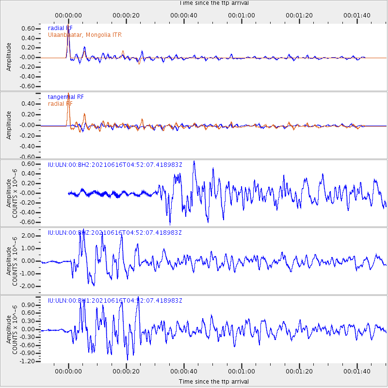
Signal To Noise
| Channel | StoN | STA | LTA |
| IU:ULN:00:BHZ:20210616T04:52:07.418983Z | 19.836681 | 7.4895246E-7 | 3.7755935E-8 |
| IU:ULN:00:BH1:20210616T04:52:07.418983Z | 12.302311 | 3.1499584E-7 | 2.5604608E-8 |
| IU:ULN:00:BH2:20210616T04:52:07.418983Z | 4.1633434 | 1.4527383E-7 | 3.4893553E-8 |
| Arrivals |
| Ps | 5.6 SECOND |
| PpPs | 19 SECOND |
| PsPs/PpSs | 24 SECOND |


