You are here: Home > Network List > MM - Myanmar National Seismic Network Stations List
> Station TGI Taung Gyi, Myanmar > Earthquake Result Viewer
TGI Taung Gyi, Myanmar - Earthquake Result Viewer
| Earthquake location: |
Seram, Indonesia |
| Earthquake latitude/longitude: |
-3.6/129.5 |
| Earthquake time(UTC): |
2021/06/16 (167) 04:43:07 GMT |
| Earthquake Depth: |
5.7 km |
| Earthquake Magnitude: |
5.9 Mww |
| Earthquake Catalog/Contributor: |
NEIC PDE/us |
|
| Network: |
MM Myanmar National Seismic Network |
| Station: |
TGI Taung Gyi, Myanmar |
| Lat/Lon: |
20.77 N/97.03 E |
| Elevation: |
1458 m |
|
| Distance: |
40.0 deg |
| Az: |
308.541 deg |
| Baz: |
123.464 deg |
| Ray Param: |
0.074659854 |
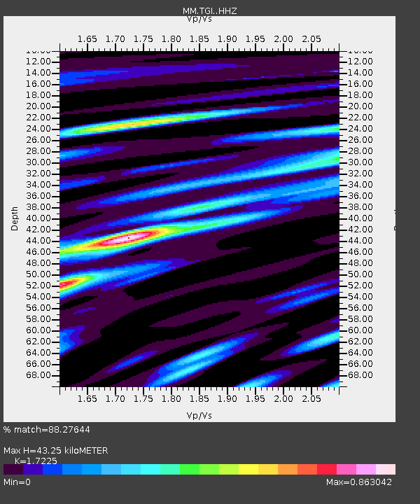
| Estimated Moho Depth: |
43.25 km |
| Estimated Crust Vp/Vs: |
1.72 |
| Assumed Crust Vp: |
6.316 km/s |
| Estimated Crust Vs: |
3.667 km/s |
| Estimated Crust Poisson's Ratio: |
0.25 |
|
| Radial Match: |
88.27644 % |
| Radial Bump: |
400 |
| Transverse Match: |
65.851105 % |
| Transverse Bump: |
400 |
| SOD ConfigId: |
25131211 |
| Insert Time: |
2021-06-30 04:50:58.902 +0000 |
| GWidth: |
2.5 |
| Max Bumps: |
400 |
| Tol: |
0.001 |
|

Signal To Noise
| Channel | StoN | STA | LTA |
| MM:TGI: :HHZ:20210616T04:50:11.889992Z | 10.081745 | 8.927273E-7 | 8.854888E-8 |
| MM:TGI: :HHN:20210616T04:50:11.889992Z | 2.4360383 | 2.9787105E-7 | 1.2227684E-7 |
| MM:TGI: :HHE:20210616T04:50:11.889992Z | 4.7927494 | 4.8297613E-7 | 1.0077225E-7 |
| Arrivals |
| Ps | 5.3 SECOND |
| PpPs | 17 SECOND |
| PsPs/PpSs | 23 SECOND |


