You are here: Home > Network List > AK - Alaska Regional Network Stations List
> Station F21K Alatna River, AK, USA > Earthquake Result Viewer
F21K Alatna River, AK, USA - Earthquake Result Viewer
| Earthquake location: |
Qinghai, China |
| Earthquake latitude/longitude: |
38.2/93.7 |
| Earthquake time(UTC): |
2021/06/16 (167) 08:48:58 GMT |
| Earthquake Depth: |
10 km |
| Earthquake Magnitude: |
5.4 Mww |
| Earthquake Catalog/Contributor: |
NEIC PDE/us |
|
| Network: |
AK Alaska Regional Network |
| Station: |
F21K Alatna River, AK, USA |
| Lat/Lon: |
67.22 N/153.48 W |
| Elevation: |
597 m |
|
| Distance: |
63.4 deg |
| Az: |
23.674 deg |
| Baz: |
305.654 deg |
| Ray Param: |
0.059627555 |
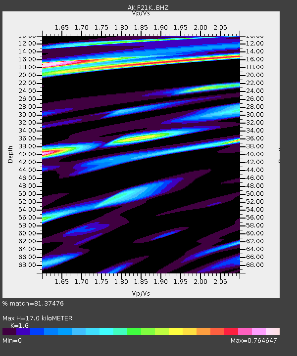
| Estimated Moho Depth: |
17.0 km |
| Estimated Crust Vp/Vs: |
1.60 |
| Assumed Crust Vp: |
6.455 km/s |
| Estimated Crust Vs: |
4.035 km/s |
| Estimated Crust Poisson's Ratio: |
0.18 |
|
| Radial Match: |
81.37476 % |
| Radial Bump: |
394 |
| Transverse Match: |
75.74748 % |
| Transverse Bump: |
327 |
| SOD ConfigId: |
25131211 |
| Insert Time: |
2021-06-30 08:50:31.955 +0000 |
| GWidth: |
2.5 |
| Max Bumps: |
400 |
| Tol: |
0.001 |
|

Signal To Noise
| Channel | StoN | STA | LTA |
| AK:F21K: :BHZ:20210616T08:58:57.11999Z | 7.790774 | 5.4376255E-7 | 6.9795696E-8 |
| AK:F21K: :BHN:20210616T08:58:57.11999Z | 3.1144648 | 1.5955811E-7 | 5.123131E-8 |
| AK:F21K: :BHE:20210616T08:58:57.11999Z | 5.2832203 | 2.2194106E-7 | 4.200867E-8 |
| Arrivals |
| Ps | 1.7 SECOND |
| PpPs | 6.5 SECOND |
| PsPs/PpSs | 8.2 SECOND |


