You are here: Home > Network List > KZ - Kazakhstan Network Stations List
> Station KKAR Karatau array,KK31, Kazakhstan > Earthquake Result Viewer
KKAR Karatau array,KK31, Kazakhstan - Earthquake Result Viewer
| Earthquake location: |
Southwestern Ryukyu Isl., Japan |
| Earthquake latitude/longitude: |
23.3/124.1 |
| Earthquake time(UTC): |
2002/03/26 (085) 03:45:48 GMT |
| Earthquake Depth: |
33 km |
| Earthquake Magnitude: |
5.8 MB, 6.6 MS, 6.4 MW, 6.4 MW |
| Earthquake Catalog/Contributor: |
WHDF/NEIC |
|
| Network: |
KZ Kazakhstan Network |
| Station: |
KKAR Karatau array,KK31, Kazakhstan |
| Lat/Lon: |
43.11 N/70.51 E |
| Elevation: |
525 m |
|
| Distance: |
48.1 deg |
| Az: |
307.637 deg |
| Baz: |
96.397 deg |
| Ray Param: |
0.069515474 |
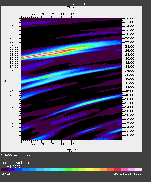
| Estimated Moho Depth: |
27.5 km |
| Estimated Crust Vp/Vs: |
1.73 |
| Assumed Crust Vp: |
6.316 km/s |
| Estimated Crust Vs: |
3.656 km/s |
| Estimated Crust Poisson's Ratio: |
0.25 |
|
| Radial Match: |
96.93442 % |
| Radial Bump: |
180 |
| Transverse Match: |
90.89056 % |
| Transverse Bump: |
400 |
| SOD ConfigId: |
20082 |
| Insert Time: |
2010-03-09 09:18:56.369 +0000 |
| GWidth: |
2.5 |
| Max Bumps: |
400 |
| Tol: |
0.001 |
|

Signal To Noise
| Channel | StoN | STA | LTA |
| KZ:KKAR: :BHN:20020326T03:53:54.624011Z | 6.2993093 | 3.8636583E-7 | 6.133464E-8 |
| KZ:KKAR: :BHE:20020326T03:53:54.624011Z | 27.445063 | 1.7315939E-6 | 6.309309E-8 |
| KZ:KKAR: :BHZ:20020326T03:53:54.624011Z | 34.6475 | 3.1993995E-6 | 9.234143E-8 |
| Arrivals |
| Ps | 3.4 SECOND |
| PpPs | 11 SECOND |
| PsPs/PpSs | 15 SECOND |


