You are here: Home > Network List > PF - Volcanologic Network of Piton de Fournaise-OVPF Stations List
> Station HIM cratere Himiltrude > Earthquake Result Viewer
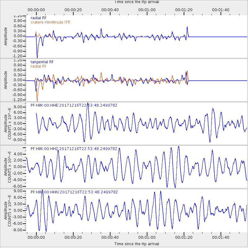
HIM cratere Himiltrude - Earthquake Result Viewer
*The percent match for this event was below the threshold and hence no stack was calculated.
| Earthquake location: |
Pacific-Antarctic Ridge |
| Earthquake latitude/longitude: |
-59.6/-151.1 |
| Earthquake time(UTC): |
2017/12/16 (350) 22:40:50 GMT |
| Earthquake Depth: |
10 km |
| Earthquake Magnitude: |
5.5 Mww |
| Earthquake Catalog/Contributor: |
NEIC PDE/us |
|
| Network: |
PF Volcanologic Network of Piton de Fournaise-OVPF |
| Station: |
HIM cratere Himiltrude |
| Lat/Lon: |
21.21 S/55.72 E |
| Elevation: |
1958 m |
|
| Distance: |
96.5 deg |
| Az: |
205.091 deg |
| Baz: |
166.646 deg |
| Ray Param: |
$rayparam |
*The percent match for this event was below the threshold and hence was not used in the summary stack. |
|
| Radial Match: |
63.044277 % |
| Radial Bump: |
400 |
| Transverse Match: |
55.117825 % |
| Transverse Bump: |
400 |
| SOD ConfigId: |
2429771 |
| Insert Time: |
2017-12-30 22:42:05.425 +0000 |
| GWidth: |
2.5 |
| Max Bumps: |
400 |
| Tol: |
0.001 |
|
Signal To Noise
| Channel | StoN | STA | LTA |
| PF:HIM:00:HHZ:20171216T22:53:48.249978Z | 0.9316921 | 1.707779E-6 | 1.8329864E-6 |
| PF:HIM:00:HHN:20171216T22:53:48.249978Z | 2.1048126 | 5.6355284E-6 | 2.677449E-6 |
| PF:HIM:00:HHE:20171216T22:53:48.249978Z | 1.878391 | 4.9763094E-6 | 2.6492405E-6 |
| Arrivals |
| Ps | |
| PpPs | |
| PsPs/PpSs | |


