You are here: Home > Network List > G - GEOSCOPE Stations List
> Station MPG Montagne des Peres, French Guyana > Earthquake Result Viewer
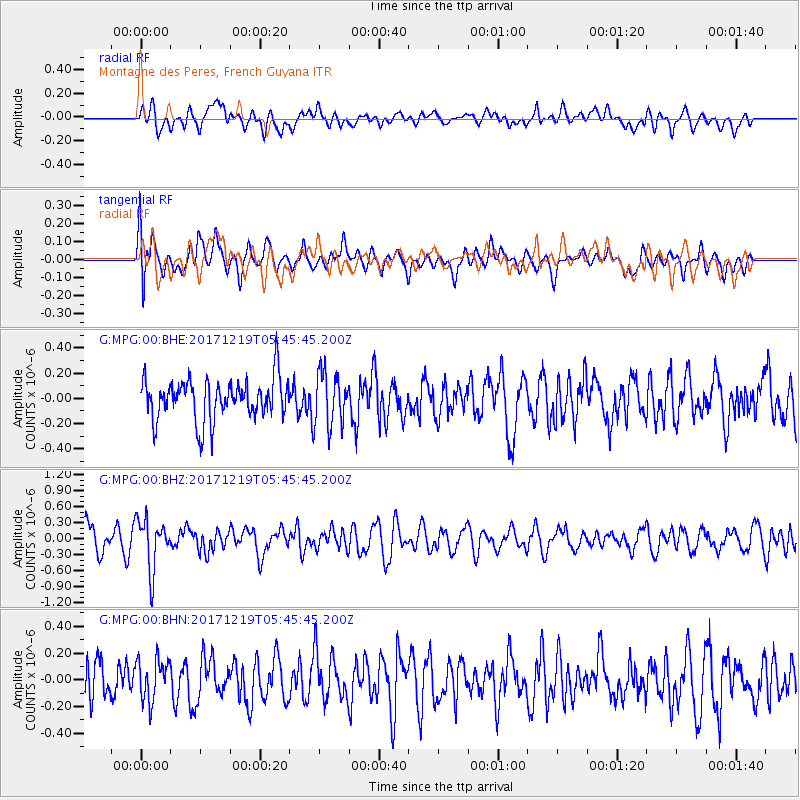
MPG Montagne des Peres, French Guyana - Earthquake Result Viewer
*The percent match for this event was below the threshold and hence no stack was calculated.
| Earthquake location: |
Southern East Pacific Rise |
| Earthquake latitude/longitude: |
-21.9/-114.2 |
| Earthquake time(UTC): |
2017/12/19 (353) 05:35:29 GMT |
| Earthquake Depth: |
10 km |
| Earthquake Magnitude: |
5.6 mb |
| Earthquake Catalog/Contributor: |
NEIC PDE/us |
|
| Network: |
G GEOSCOPE |
| Station: |
MPG Montagne des Peres, French Guyana |
| Lat/Lon: |
5.11 N/52.64 W |
| Elevation: |
147 m |
|
| Distance: |
66.0 deg |
| Az: |
73.595 deg |
| Baz: |
243.413 deg |
| Ray Param: |
$rayparam |
*The percent match for this event was below the threshold and hence was not used in the summary stack. |
|
| Radial Match: |
53.315685 % |
| Radial Bump: |
400 |
| Transverse Match: |
57.02164 % |
| Transverse Bump: |
400 |
| SOD ConfigId: |
2429771 |
| Insert Time: |
2018-01-02 05:36:36.182 +0000 |
| GWidth: |
2.5 |
| Max Bumps: |
400 |
| Tol: |
0.001 |
|
Signal To Noise
| Channel | StoN | STA | LTA |
| G:MPG:00:BHZ:20171219T05:45:45.200Z | 2.1125097 | 4.696915E-7 | 2.2233814E-7 |
| G:MPG:00:BHN:20171219T05:45:45.200Z | 1.016977 | 1.5667831E-7 | 1.540628E-7 |
| G:MPG:00:BHE:20171219T05:45:45.200Z | 1.3199731 | 2.110396E-7 | 1.5988174E-7 |
| Arrivals |
| Ps | |
| PpPs | |
| PsPs/PpSs | |


