You are here: Home > Network List > KZ - Kazakhstan Network Stations List
> Station KKAR Karatau array,KK31, Kazakhstan > Earthquake Result Viewer
KKAR Karatau array,KK31, Kazakhstan - Earthquake Result Viewer
| Earthquake location: |
Philippine Islands Region |
| Earthquake latitude/longitude: |
20.3/122.0 |
| Earthquake time(UTC): |
2008/03/29 (089) 08:09:47 GMT |
| Earthquake Depth: |
16 km |
| Earthquake Magnitude: |
5.5 MB, 5.3 MS, 5.5 MW |
| Earthquake Catalog/Contributor: |
WHDF/NEIC |
|
| Network: |
KZ Kazakhstan Network |
| Station: |
KKAR Karatau array,KK31, Kazakhstan |
| Lat/Lon: |
43.11 N/70.51 E |
| Elevation: |
525 m |
|
| Distance: |
48.5 deg |
| Az: |
310.078 deg |
| Baz: |
101.234 deg |
| Ray Param: |
0.06931104 |
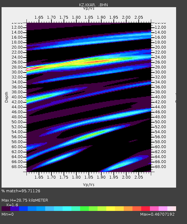
| Estimated Moho Depth: |
28.75 km |
| Estimated Crust Vp/Vs: |
1.60 |
| Assumed Crust Vp: |
6.316 km/s |
| Estimated Crust Vs: |
3.947 km/s |
| Estimated Crust Poisson's Ratio: |
0.18 |
|
| Radial Match: |
95.71126 % |
| Radial Bump: |
278 |
| Transverse Match: |
84.247894 % |
| Transverse Bump: |
400 |
| SOD ConfigId: |
2504 |
| Insert Time: |
2010-03-09 09:21:46.658 +0000 |
| GWidth: |
2.5 |
| Max Bumps: |
400 |
| Tol: |
0.001 |
|

Signal To Noise
| Channel | StoN | STA | LTA |
| KZ:KKAR: :BHN:20080329T08:17:58.700004Z | 1.9016694 | 3.102386E-7 | 1.6314013E-7 |
| KZ:KKAR: :BHE:20080329T08:17:58.700004Z | 1.0646911 | 8.022821E-8 | 7.535352E-8 |
| KZ:KKAR: :BHZ:20080329T08:17:58.700004Z | 2.601789 | 1.3980045E-7 | 5.3732435E-8 |
| Arrivals |
| Ps | 2.9 SECOND |
| PpPs | 11 SECOND |
| PsPs/PpSs | 14 SECOND |


