You are here: Home > Network List > GS - US Geological Survey Networks Stations List
> Station OK051 E0350 and S34600 Roads, Ralston, OK > Earthquake Result Viewer
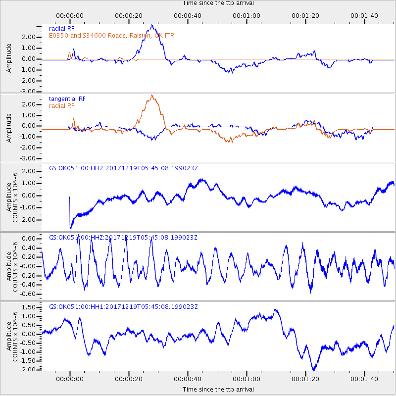
OK051 E0350 and S34600 Roads, Ralston, OK - Earthquake Result Viewer
*The percent match for this event was below the threshold and hence no stack was calculated.
| Earthquake location: |
Southern East Pacific Rise |
| Earthquake latitude/longitude: |
-21.9/-114.2 |
| Earthquake time(UTC): |
2017/12/19 (353) 05:35:29 GMT |
| Earthquake Depth: |
10 km |
| Earthquake Magnitude: |
5.6 mb |
| Earthquake Catalog/Contributor: |
NEIC PDE/us |
|
| Network: |
GS US Geological Survey Networks |
| Station: |
OK051 E0350 and S34600 Roads, Ralston, OK |
| Lat/Lon: |
36.51 N/96.84 W |
| Elevation: |
263 m |
|
| Distance: |
60.4 deg |
| Az: |
16.1 deg |
| Baz: |
198.639 deg |
| Ray Param: |
$rayparam |
*The percent match for this event was below the threshold and hence was not used in the summary stack. |
|
| Radial Match: |
37.696445 % |
| Radial Bump: |
400 |
| Transverse Match: |
25.478392 % |
| Transverse Bump: |
400 |
| SOD ConfigId: |
2429771 |
| Insert Time: |
2018-01-02 05:37:12.942 +0000 |
| GWidth: |
2.5 |
| Max Bumps: |
400 |
| Tol: |
0.001 |
|
Signal To Noise
| Channel | StoN | STA | LTA |
| GS:OK051:00:HHZ:20171219T05:45:08.199023Z | 0.9615626 | 3.3048616E-7 | 3.43697E-7 |
| GS:OK051:00:HH1:20171219T05:45:08.199023Z | 1.5797167 | 8.530451E-7 | 5.399988E-7 |
| GS:OK051:00:HH2:20171219T05:45:08.199023Z | 0.8796011 | 6.2908447E-7 | 7.151929E-7 |
| Arrivals |
| Ps | |
| PpPs | |
| PsPs/PpSs | |


