You are here: Home > Network List > CN - Canadian National Seismograph Network Stations List
> Station INK INUVIK, NT > Earthquake Result Viewer
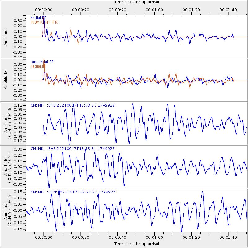
INK INUVIK, NT - Earthquake Result Viewer
*The percent match for this event was below the threshold and hence no stack was calculated.
| Earthquake location: |
Tonga Islands Region |
| Earthquake latitude/longitude: |
-17.2/-172.8 |
| Earthquake time(UTC): |
2021/06/17 (168) 13:41:03 GMT |
| Earthquake Depth: |
10 km |
| Earthquake Magnitude: |
5.5 mww |
| Earthquake Catalog/Contributor: |
NEIC PDE/us |
|
| Network: |
CN Canadian National Seismograph Network |
| Station: |
INK INUVIK, NT |
| Lat/Lon: |
68.31 N/133.53 W |
| Elevation: |
44 m |
|
| Distance: |
89.9 deg |
| Az: |
13.607 deg |
| Baz: |
217.211 deg |
| Ray Param: |
$rayparam |
*The percent match for this event was below the threshold and hence was not used in the summary stack. |
|
| Radial Match: |
60.585903 % |
| Radial Bump: |
331 |
| Transverse Match: |
58.16762 % |
| Transverse Bump: |
400 |
| SOD ConfigId: |
25131211 |
| Insert Time: |
2021-07-01 14:07:03.593 +0000 |
| GWidth: |
2.5 |
| Max Bumps: |
400 |
| Tol: |
0.001 |
|
Signal To Noise
| Channel | StoN | STA | LTA |
| CN:INK: :BHZ:20210617T13:53:31.174992Z | 3.0185218 | 1.732634E-7 | 5.7400083E-8 |
| CN:INK: :BHN:20210617T13:53:31.174992Z | 1.3646055 | 6.523356E-8 | 4.7803965E-8 |
| CN:INK: :BHE:20210617T13:53:31.174992Z | 0.8339979 | 4.8751147E-8 | 5.845476E-8 |
| Arrivals |
| Ps | |
| PpPs | |
| PsPs/PpSs | |


